IMAGES TAKEN NEAR TO
Upton Road, BEXLEYHEATH, DA6 8LN
Introduction
This page details the photographs taken nearby to Upton Road, DA6 8LN by members of the Geograph project.
The Geograph project started in 2005 with the aim of publishing, organising and preserving representative images for every square kilometre of Great Britain, Ireland and the Isle of Man.

There are currently over 7.5m images from over14,400 individuals and you can help contribute to the project by visiting https://www.geograph.org.uk
Image Map
Images are licensed for reuse under creativecommons.org/licenses/by-sa/2.0
Notes
- Clicking on the map will re-center to the selected point.
- The higher the marker number, the further away the image location is from the centre of the postcode.
Image Listing (96 Images Found)
Images are licensed for reuse under creativecommons.org/licenses/by-sa/2.0
Image
Details
Distance
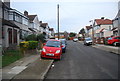
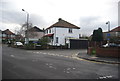
6
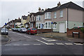
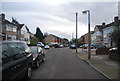
Hansol Road, Bexleyheath
Seen from Upton Road.
Image: © Stephen McKay
Taken: 26 Jul 2015
0.06 miles
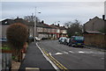
7
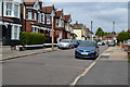
Robin Hood Lane, Bexleyheath
Robin Hood Lane leads down from Lion Road, adjacent to the Robin Hood & Little John pub, to Upton Road.
Image: © Stephen McKay
Taken: 26 Jul 2015
0.08 miles
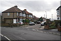
9
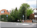
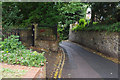
West end of Robin Hood Lane
This end of the lane at its junction with Upton Road is signed as "no through road except cycles". Although as can be seen here with this lady pushing her bicycle, it is a steepish climb up to the junction,
Image: © Stephen Craven
Taken: 4 May 2013
0.08 miles