IMAGES TAKEN NEAR TO
Aspen Green, ERITH, DA18 4HT
Introduction
This page details the photographs taken nearby to Aspen Green, DA18 4HT by members of the Geograph project.
The Geograph project started in 2005 with the aim of publishing, organising and preserving representative images for every square kilometre of Great Britain, Ireland and the Isle of Man.

There are currently over 7.5m images from over14,400 individuals and you can help contribute to the project by visiting https://www.geograph.org.uk
Image Map
Images are licensed for reuse under creativecommons.org/licenses/by-sa/2.0
Notes
- Clicking on the map will re-center to the selected point.
- The higher the marker number, the further away the image location is from the centre of the postcode.
Image Listing (33 Images Found)
Images are licensed for reuse under creativecommons.org/licenses/by-sa/2.0
Image
Details
Distance
1
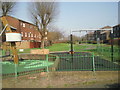
Playground at Aspen Green, Thamesmead
This scene is typical of the newer housing and landscaping at Thamesmead. The small playground is relatively new.
Image: © Marathon
Taken: 8 Mar 2011
0.07 miles
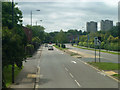
2
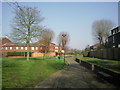
Aspen Green, Thamesmead
Typical of the newer housing and landscaping at Thamesmead. There is a small playground in the middle distance.
Image: © Marathon
Taken: 8 Mar 2011
0.07 miles
3
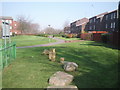
Landscaping at Aspen Green, Thamesmead
This scene is typical of the newer housing and landscaping at Thamesmead.
Image: © Marathon
Taken: 8 Mar 2011
0.07 miles
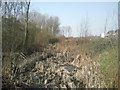
4
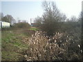
Overgrown drainage ditch at Veridion Park, Thamesmead
Because Thamesmead is built on former marshland, drainage dykes are still to be seen throughout the development. Some have been landscaped, others have just been left as can be seen here. This rather overgrown example is viewed from Waldrist Way on the Veridion Park Industrial Estate. Belvedere station is just beyond the gasholders in the distance.
Image: © Marathon
Taken: 8 Mar 2011
0.11 miles
5
At the Thames Innovation Centre bus stop
Viewed from a bus on route 180.
Image: © Robin Webster
Taken: 25 Jun 2011
0.12 miles
6
Dyke at Veridion Park, Thamesmead
Because Thamesmead is built on former marshland, drainage dykes are still to be seen throughout the development. Some have been landscaped, others have just been left as can be seen here. This rather overgrown example is viewed from Waldrist Way on the Veridion Park Industrial Estate.
Image: © Marathon
Taken: 8 Mar 2011
0.15 miles
7
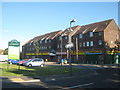
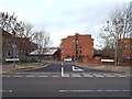
Lime Row Shopping Centre, Belvedere
Close to Northwood Place, along Yarnton Way.
Image: © David Anstiss
Taken: 21 Aug 2011
0.16 miles
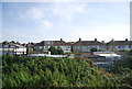
9
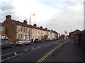
Abbey Road, Belvedere
Abbey Road in Belvedere, in south east London.
Image: © Malc McDonald
Taken: 30 Dec 2017
0.17 miles
10
Laymarsh Close, Belvedere
Laymarsh Close in Belvedere, in south east London.
Image: © Malc McDonald
Taken: 30 Dec 2017
0.18 miles