IMAGES TAKEN NEAR TO
Picardy Road, BELVEDERE, DA17 5QN
Introduction
This page details the photographs taken nearby to Picardy Road, DA17 5QN by members of the Geograph project.
The Geograph project started in 2005 with the aim of publishing, organising and preserving representative images for every square kilometre of Great Britain, Ireland and the Isle of Man.

There are currently over 7.5m images from over14,400 individuals and you can help contribute to the project by visiting https://www.geograph.org.uk
Image Map
Images are licensed for reuse under creativecommons.org/licenses/by-sa/2.0
Notes
- Clicking on the map will re-center to the selected point.
- The higher the marker number, the further away the image location is from the centre of the postcode.
Image Listing (53 Images Found)
Images are licensed for reuse under creativecommons.org/licenses/by-sa/2.0
Image
Details
Distance
3
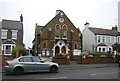
Belvedere and Erith Congregational Church
Image: © N Chadwick
Taken: 5 Jan 2014
0.04 miles
5
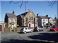
Congregational Church, Picardy Road, Belvedere, Kent
This very pleasant building seems to be about 100 years old, but there has been a church on this site for longer than that: the First Edition six-inch map labels a "Bapt. Ch." at this spot, which was then almost in open country.
Image: © Dr Neil Clifton
Taken: 5 Apr 2006
0.05 miles