IMAGES TAKEN NEAR TO
Abbey Hill Road, SIDCUP, DA15 9AX
Introduction
This page details the photographs taken nearby to Abbey Hill Road, DA15 9AX by members of the Geograph project.
The Geograph project started in 2005 with the aim of publishing, organising and preserving representative images for every square kilometre of Great Britain, Ireland and the Isle of Man.

There are currently over 7.5m images from over14,400 individuals and you can help contribute to the project by visiting https://www.geograph.org.uk
Image Map
Images are licensed for reuse under creativecommons.org/licenses/by-sa/2.0
Notes
- Clicking on the map will re-center to the selected point.
- The higher the marker number, the further away the image location is from the centre of the postcode.
Image Listing (37 Images Found)
Images are licensed for reuse under creativecommons.org/licenses/by-sa/2.0
Image
Details
Distance
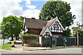
4
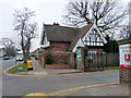
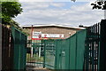
Lodge at entrance to Hurstmere School
A late 19th century grade II listed building, originally at a gate of Lamorbey Park.
Image: © Robin Webster
Taken: 14 Mar 2012
0.07 miles
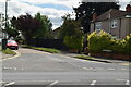
10
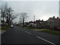
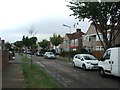
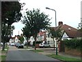
Hurst Road, Sidcup
These houses along a trunk road are a typical ribbon development from the 1930s, when major roads were built between towns with semis along them sometimes for miles.
Image: © David Howard
Taken: 6 Jan 2013
0.13 miles