IMAGES TAKEN NEAR TO
East Rochester Way, SIDCUP, DA15 8TQ
Introduction
This page details the photographs taken nearby to East Rochester Way, DA15 8TQ by members of the Geograph project.
The Geograph project started in 2005 with the aim of publishing, organising and preserving representative images for every square kilometre of Great Britain, Ireland and the Isle of Man.

There are currently over 7.5m images from over14,400 individuals and you can help contribute to the project by visiting https://www.geograph.org.uk
Image Map
Images are licensed for reuse under creativecommons.org/licenses/by-sa/2.0
Notes
- Clicking on the map will re-center to the selected point.
- The higher the marker number, the further away the image location is from the centre of the postcode.
Image Listing (58 Images Found)
Images are licensed for reuse under creativecommons.org/licenses/by-sa/2.0
Image
Details
Distance
2
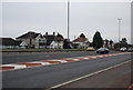
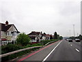
A2 at Falconwood
The trunk A2 road passing through Falconwood in South East London.
Image: © Malc McDonald
Taken: 15 Mar 2014
0.02 miles
4
Cycle route by the A2
The cycle route comes behind the camera from Falconwood, Greenwich and Central London and turns right to Blackfen and Bexleyheath.
Image: © Robin Webster
Taken: 26 Feb 2012
0.03 miles
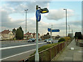
5
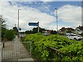
Cycle signage, Orchard Road West
An official cycle route from Greenwich to Bexleyheath uses the pavement alongside the A2 from Falconwood junction to this point, then diverts away from the main road into a housing estate.
Image: © Stephen Craven
Taken: 31 May 2022
0.03 miles
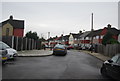
6

Vitage street nameplate, East Rochester Way, Sidcup
Image: © Chris Whippet
Taken: 6 Apr 2014
0.03 miles

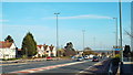
9
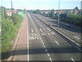
A2 Rochester Way East
Looking towards London, the slip road on the left leads to Falconwood. On the skyline to the right are Shepherdleas and Oxleas Woods, and the water tower on the summit of Shooters Hill can just be made out.
Image: © Marathon
Taken: 4 Jul 2010
0.04 miles
