IMAGES TAKEN NEAR TO
Dering Way, GRAVESEND, DA12 2FP
Introduction
This page details the photographs taken nearby to Dering Way, DA12 2FP by members of the Geograph project.
The Geograph project started in 2005 with the aim of publishing, organising and preserving representative images for every square kilometre of Great Britain, Ireland and the Isle of Man.

There are currently over 7.5m images from over14,400 individuals and you can help contribute to the project by visiting https://www.geograph.org.uk
Image Map
Images are licensed for reuse under creativecommons.org/licenses/by-sa/2.0
Notes
- Clicking on the map will re-center to the selected point.
- The higher the marker number, the further away the image location is from the centre of the postcode.
Image Listing (63 Images Found)
Images are licensed for reuse under creativecommons.org/licenses/by-sa/2.0
Image
Details
Distance
2
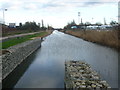
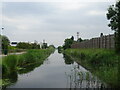
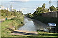
The Thames & Medway Canal near Mark Lane
After weeks of heavy rain and flooding inland The Thames & Medway Canal appeared to be much fuller than usual. This part of the Thames & Medway Canal was opened between Gravesend and Higham in 1801 and continued in use until 1934.
A more typical view of the canal a little way to the east can be seen at http://www.geograph.org.uk/photo/2118631
To find out more about the Thames & Medway Canal and the plans to restore it visit http://www.thamesmedway.co.uk/
Image: © Marathon
Taken: 9 Jan 2014
0.09 miles
4
The Thames & Medway Canal near Mark Lane
After weeks of heavy rain and flooding inland The Thames & Medway Canal appeared to be much fuller than usual. This part of the Thames & Medway Canal was opened between Gravesend and Higham in 1801 and continued in use until 1934.
A more typical view of the canal a little way to the east can be seen at http://www.geograph.org.uk/photo/2118631
To find out more about the Thames & Medway Canal and the plans to restore it visit http://www.thamesmedway.co.uk/
Image: © Marathon
Taken: 9 Jan 2014
0.11 miles
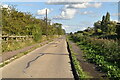
6
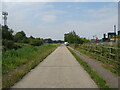
Thames & Medway Canal
National Cycle Route 1 runs beside on the left.
Image: © JThomas
Taken: 23 Jun 2022
0.12 miles
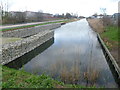
7
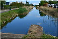
Current Gravesend end of the former Thames and Medway Canal
The canal originally ended at a basin with a lock into the Thames, now a marina. Approximately 675m of canal from here to the basin have been infilled.
Image: © David Martin
Taken: 25 May 2019
0.12 miles
8
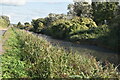
National Cycle Route 1 beside the Thames & Medway Canal
Towards Gravesend.
Image: © JThomas
Taken: 23 Jun 2022
0.12 miles
10
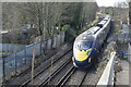
Eastbound Javelin train approaching footbridge at Denton
Image: © David Martin
Taken: 17 Feb 2022
0.13 miles