IMAGES TAKEN NEAR TO
Pecks Brow, NORTHWICH, CW8 2RT
Introduction
This page details the photographs taken nearby to Pecks Brow, CW8 2RT by members of the Geograph project.
The Geograph project started in 2005 with the aim of publishing, organising and preserving representative images for every square kilometre of Great Britain, Ireland and the Isle of Man.

There are currently over 7.5m images from over14,400 individuals and you can help contribute to the project by visiting https://www.geograph.org.uk
Image Map
Images are licensed for reuse under creativecommons.org/licenses/by-sa/2.0
Notes
- Clicking on the map will re-center to the selected point.
- The higher the marker number, the further away the image location is from the centre of the postcode.
Image Listing (5 Images Found)
Images are licensed for reuse under creativecommons.org/licenses/by-sa/2.0
Image
Details
Distance
2
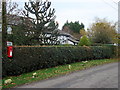
Oakhill
Postbox and cottages opposite Oakhill Farm.
Image: © David Marten
Taken: 25 Nov 2006
0.08 miles
3
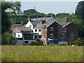
A jumble of cottages/houses
Seen from Pickering's Cut on the Weaver Navigation. The map does not provide a name for this small cluster of habitation. The aerial view shows a clear match.
Image: © Chris Allen
Taken: 10 Jun 2018
0.21 miles
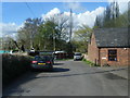
5
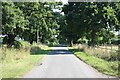
Crewood Common Road
Heading northeast along Crewood Common Road.
Image: © Jeff Buck
Taken: 11 Aug 2022
0.22 miles