IMAGES TAKEN NEAR TO
Douglas Lane, WINSFORD, CW7 4BH
Introduction
This page details the photographs taken nearby to Douglas Lane, CW7 4BH by members of the Geograph project.
The Geograph project started in 2005 with the aim of publishing, organising and preserving representative images for every square kilometre of Great Britain, Ireland and the Isle of Man.

There are currently over 7.5m images from over14,400 individuals and you can help contribute to the project by visiting https://www.geograph.org.uk
Image Map
Images are licensed for reuse under creativecommons.org/licenses/by-sa/2.0
Notes
- Clicking on the map will re-center to the selected point.
- The higher the marker number, the further away the image location is from the centre of the postcode.
Image Listing (2 Images Found)
Images are licensed for reuse under creativecommons.org/licenses/by-sa/2.0
Image
Details
Distance
1
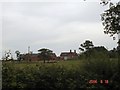
Woodside Farm, Wettenhall
Woodside Farm, Wettenhall, seen from the (long) drive, which is also a public footpath. Big herd of beef cattle here - and signs of the usual redevelopment of outbuildings as residential accommodation (?) - resulting in obstruction of the footpath - hopefully only temporarily.
Image: © Mike Harris
Taken: 18 Jun 2006
0.00 miles
2
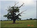
Blasted oak, Wettenhall
Blasted oak tree in field near Woodside Farm, Wettenhall. Taken from the footpath running west, north and then NE to Darnhall. The Darnhall radio telescope (linked to Jodrell Bank) is just visible in the distance, immediately to the right of the tree. Field used for grazing beef cattle.
Image: © Mike Harris
Taken: 18 Jun 2006
0.12 miles