IMAGES TAKEN NEAR TO
High Street, TARPORLEY, CW6 0DR
Introduction
This page details the photographs taken nearby to High Street, CW6 0DR by members of the Geograph project.
The Geograph project started in 2005 with the aim of publishing, organising and preserving representative images for every square kilometre of Great Britain, Ireland and the Isle of Man.

There are currently over 7.5m images from over14,400 individuals and you can help contribute to the project by visiting https://www.geograph.org.uk
Image Map
Images are licensed for reuse under creativecommons.org/licenses/by-sa/2.0
Notes
- Clicking on the map will re-center to the selected point.
- The higher the marker number, the further away the image location is from the centre of the postcode.
Image Listing (56 Images Found)
Images are licensed for reuse under creativecommons.org/licenses/by-sa/2.0
Image
Details
Distance
2
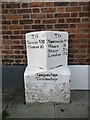
Old Milestone in High Street, Tarporley
Carved stone post by the UC road (was A51), in parish of Tarporley (Vale Royal District), High Street, in pavement, back to brick wall of building, on West side of road. Chester Road stone, erected by the Nantwich & Woore turnpike trust in the 19th century.
Inscription reads:-
: TO / Tarvin 5M / Chester 10 : : TaRpoRley / Township : : TO / Nantwich 9M / Woore 18 / Stone 30 / London 172 :
Grade II listed.
List Entry Number: 1136670 https://historicengland.org.uk/listing/the-list/list-entry/1136670
Milestone Society National ID: CH_CHNW10
Image: © Gillian Oakes
Taken: 1 Jan 2003
0.02 miles
8
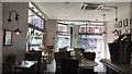
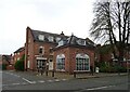
Inside The Coast
The Coast is an upmarket Italian restaurant in Tarporley.
Image: © Jonathan Hutchins
Taken: 27 Aug 2017
0.02 miles
9
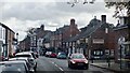
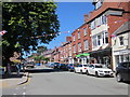
The High Street, Tarporley
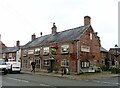
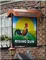
Tarporley is a large (population 2,614 at the 2011 Census) picturesque village on the west of the Cheshire Plain. It is believed that the High Street was part of a Roman Road called the Via Devana which ran from Chester to Colchester and the Domesday entry indicates that Tarporley was a small agricultural settlement in Norman times (http://www.tarporley.org.uk/about/history/ History of Tarporley). During the eighteenth and nineteenth centuries, the village was on the route used by many traders travelling by coach between London and Chester as well as those dealing in salt mined in nearby Nantwich and it developed with many hostelries to revive the weary traveller (http://www.tarporley.net/main/about.htm About Tarporley). Two of those hostelries can be seen on the right hand side of the high street in this photograph. The Rising Sun is Grade II-listed (Historic England List Entry Number: 1138443 http://www.heritagegateway.org.uk/Gateway/Results_Single.aspx?uid=1138443&resourceID=5 Heritage Gateway) and, further along the street, with the flags outside, The Swan is listed at Grade II* (List Entry Number: 1136655 http://www.heritagegateway.org.uk/Gateway/Results_Single.aspx?uid=1136655&resourceID=5 ).
Image: © David Dixon
Taken: 11 Apr 2016
0.02 miles
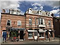
10
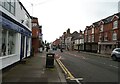
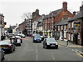
High Street, Tarporley
Looking north along High Street in Tarporley.
Image: © Jeff Buck
Taken: 22 Jun 2018
0.03 miles