The High Street, Tarporley
Introduction
The photograph on this page of The High Street, Tarporley by David Dixon as part of the Geograph project.
The Geograph project started in 2005 with the aim of publishing, organising and preserving representative images for every square kilometre of Great Britain, Ireland and the Isle of Man.

There are currently over 7.5m images from over 14,400 individuals and you can help contribute to the project by visiting https://www.geograph.org.uk
The High Street, Tarporley
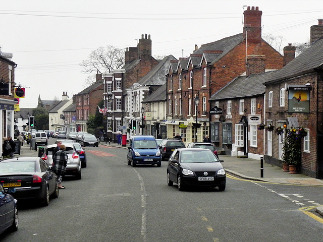
Image: © David Dixon Taken: 11 Apr 2016
Tarporley is a large (population 2,614 at the 2011 Census) picturesque village on the west of the Cheshire Plain. It is believed that the High Street was part of a Roman Road called the Via Devana which ran from Chester to Colchester and the Domesday entry indicates that Tarporley was a small agricultural settlement in Norman times (http://www.tarporley.org.uk/about/history/ History of Tarporley). During the eighteenth and nineteenth centuries, the village was on the route used by many traders travelling by coach between London and Chester as well as those dealing in salt mined in nearby Nantwich and it developed with many hostelries to revive the weary traveller (http://www.tarporley.net/main/about.htm About Tarporley). Two of those hostelries can be seen on the right hand side of the high street in this photograph. The Rising Sun is Grade II-listed (Historic England List Entry Number: 1138443 http://www.heritagegateway.org.uk/Gateway/Results_Single.aspx?uid=1138443&resourceID=5 Heritage Gateway) and, further along the street, with the flags outside, The Swan is listed at Grade II* (List Entry Number: 1136655 http://www.heritagegateway.org.uk/Gateway/Results_Single.aspx?uid=1136655&resourceID=5 ).
Images are licensed for reuse under creativecommons.org/licenses/by-sa/2.0
Image Location
Latitude
53.159186
Longitude
-2.668772