IMAGES TAKEN NEAR TO
Wrenbury Frith, NANTWICH, CW5 8HL
Introduction
This page details the photographs taken nearby to Wrenbury Frith, CW5 8HL by members of the Geograph project.
The Geograph project started in 2005 with the aim of publishing, organising and preserving representative images for every square kilometre of Great Britain, Ireland and the Isle of Man.

There are currently over 7.5m images from over14,400 individuals and you can help contribute to the project by visiting https://www.geograph.org.uk
Image Map
Images are licensed for reuse under creativecommons.org/licenses/by-sa/2.0
Notes
- Clicking on the map will re-center to the selected point.
- The higher the marker number, the further away the image location is from the centre of the postcode.
Image Listing (6 Images Found)
Images are licensed for reuse under creativecommons.org/licenses/by-sa/2.0
Image
Details
Distance
1
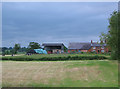
Cholmondeley Brook Farm
A typical red-brick farmhouse with brick barn behind, set in flat cattle pasture studded with mature deciduous trees. View from the footpath from Holtridge Road to Norbury Common on a stormy afternoon
Image: © Espresso Addict
Taken: 22 Jun 2006
0.01 miles
2
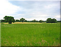
Fallow field, Holtridge
The Holtridge area is fairly flat, with a mixture of fallow land and hay fields. View immediately to the west of Holtridge road, near the Cholmondeley Brook Farm track
Image: © Espresso Addict
Taken: 22 Jun 2006
0.09 miles
3
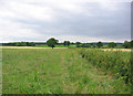
Farmland at Holtridge
Near Cholmondeley Brook Farm. The path from Holtridge road to Norbury Common runs through the fallow field to the left of the hedge
Image: © Espresso Addict
Taken: 22 Jun 2006
0.09 miles
4
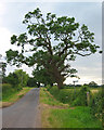
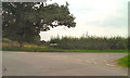
Leaning tree, Holtridge
Both tree and footpath sign lean towards the road at the Holtridge T-junction
Image: © Espresso Addict
Taken: 22 Jun 2006
0.19 miles
5
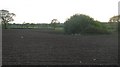
Small pond in a ploughed field
The clump of shrubs surrounds a small pond.
Image: © Richard Webb
Taken: 1 May 2009
0.20 miles