IMAGES TAKEN NEAR TO
Dairyfields Road, NANTWICH, CW5 7TD
Introduction
This page details the photographs taken nearby to Dairyfields Road, CW5 7TD by members of the Geograph project.
The Geograph project started in 2005 with the aim of publishing, organising and preserving representative images for every square kilometre of Great Britain, Ireland and the Isle of Man.

There are currently over 7.5m images from over14,400 individuals and you can help contribute to the project by visiting https://www.geograph.org.uk
Image Map
Images are licensed for reuse under creativecommons.org/licenses/by-sa/2.0
Notes
- Clicking on the map will re-center to the selected point.
- The higher the marker number, the further away the image location is from the centre of the postcode.
Image Listing (13 Images Found)
Images are licensed for reuse under creativecommons.org/licenses/by-sa/2.0
Image
Details
Distance
1

Concrete works, Trickett's Lane, Willaston
A narrow industrial area between Trickett's Lane and the railway line houses a ready-mix concrete works (shown) as well as plant hire, joinery and a waste transfer station. The Nantwich-Crewe railway line runs just beyond the trees
Image: © Espresso Addict
Taken: 26 Feb 2007
0.05 miles
2
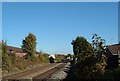
Train approaching Willaston level crossing
On the line from Crewe to Nantwich
Image: © Margaret Sutton
Taken: 25 Oct 2010
0.07 miles
3
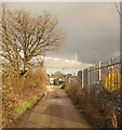
Trickett's Lane, Willaston
A narrow, single-track, dead-end lane on the east of Willaston, adjacent to the Nantwich-Crewe railway line. To the left is open pasture, to the right an industrial estate
Image: © Espresso Addict
Taken: 26 Feb 2007
0.08 miles
4
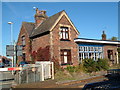
Disused railway station at Willaston near to Crewe
On the Crewe to Nantwich line. Trains still run along the line, but the station has been closed for about 50 years.
Image: © Margaret Sutton
Taken: 25 Oct 2010
0.08 miles
7
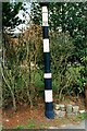
Old Direction Sign - Signpost by Wistaston Road, Willaston parish
Lost finial - no arms; Cheshire CCC octagonal by the UC road, in parish of Willaston (Crewe and Nantwich District), Wistaton Road junction with Park Road, near level crossing.
Surveyed
Milestone Society National ID: CH_SJ6752B
Image: © Milestone Society
Taken: Unknown
0.15 miles
8
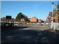
Level crossing at Willaston near Crewe
On Wistaston Road. The line runs from Crewe to Shrewsbury via Nantwich.
Image: © Margaret Sutton
Taken: 25 Oct 2010
0.16 miles
10
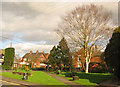
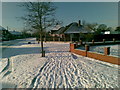
War memorial garden, Willaston
Small garden at the junction of Wistaston Road and Moorfields on the east of Willaston village with a remembrance plaque 'We will remember' (left) and the Willaston village sign
Image: © Espresso Addict
Taken: 26 Feb 2007
0.21 miles