IMAGES TAKEN NEAR TO
Stephenson Street, NANTWICH, CW5 6SS
Introduction
This page details the photographs taken nearby to Stephenson Street, CW5 6SS by members of the Geograph project.
The Geograph project started in 2005 with the aim of publishing, organising and preserving representative images for every square kilometre of Great Britain, Ireland and the Isle of Man.

There are currently over 7.5m images from over14,400 individuals and you can help contribute to the project by visiting https://www.geograph.org.uk
Image Map
Images are licensed for reuse under creativecommons.org/licenses/by-sa/2.0
Notes
- Clicking on the map will re-center to the selected point.
- The higher the marker number, the further away the image location is from the centre of the postcode.
Image Listing (14 Images Found)
Images are licensed for reuse under creativecommons.org/licenses/by-sa/2.0
Image
Details
Distance
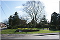
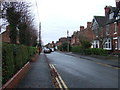
1
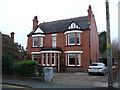
Victorian villa, Wistaston Road, Willaston
Wistaston Road runs north-south at the eastern edge of the village of Willaston, with a mixture of housing dating from the 1870s-90s (detached villas, semis & terraces), as well as late 20th century infill (left). The substantial late-Victorian red-brick detached villa (right) is typical of the Victorian houses lining the street in the northern part of the square
Image: © Espresso Addict
Taken: 26 Feb 2007
0.12 miles
2
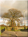
The end of the road
Magnificent tree at the end of Moorfields, marking the eastern extremity of the village of Willaston
Image: © Espresso Addict
Taken: 26 Feb 2007
0.13 miles
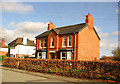
5
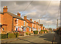
Moorfields, E Willaston
Moorfields is a cul-de-sac which runs east from Wistaston Road at the eastern edge of the village of Willaston. These late Victorian red-brick semis are at the western end of the street, and are typical of the older houses in the area
Image: © Espresso Addict
Taken: 26 Feb 2007
0.16 miles
6
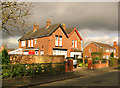
Victorian semi, Moorfields, E Willaston
Unusual diamond patterning in purple brick marks this pair of semi-detached red-brick houses, probably late Victorian in date, at the junction of Moorfields and Wistaston Road, on the east of the village of Willaston. The house on the right shows the infilling of late 20th century houses among those dating from the previous century that has occurred on both streets
Image: © Espresso Addict
Taken: 26 Feb 2007
0.16 miles
7
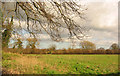
Pasture near Willaston
Flat pasture lying east of Willaston and south of Wistaston. The trees in the distance (beyond the nearest field boundary) mark the line of Valley Brook. View east from the end of the Moorfields cul-de-sac on a squally February afternoon
Image: © Espresso Addict
Taken: 26 Feb 2007
0.16 miles
8
Old Milepost by the A534, Crewe Road, Wistaston
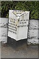
Cast iron post by the A534, in parish of Wistaston (Crewe and Nantwich District), South West of Huntsback Farm; South of Wistaston road junction, in pavement, back to garden wall, on North West side of road. Cast iron CCC1898, erected by the County Council in the 19th century.
Inscription reads:-
: CREWE / 2 MILES / HASLINGTON 4 / WHEELOCK 6½ / SANDBACH 8 / CONGLETON 15 : : CHESHIRE / 1898 / COUNTY COUNCIL : : NANTWICH / 2 MILES / WHITCHURCH 13 :
Maker:-
: W H SMITH & CO / MAKERS / WHITCHURCH :
Milestone Society National ID: CH_NWCO02
Image: © J Higgins
Taken: 1 Mar 2004
0.19 miles
9
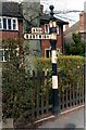
Old Direction Sign - Signpost by the A534, Crewe Road, Wistaston
Pawn finial - 1 arm; Cheshire CCC octagonal by the A534, in parish of Wistaston (Crewe and Nantwich District), No 397 Crewe Road, opposite junction with Wistaston Road.
Loss report from M Bardell.
Lost? Top of truncated column still visible buried in hedge, Streetview May 2018.
Cheshire HER listed.
SMR Number: 5486 https://www.heritagegateway.org.uk/Gateway/Results_Single.aspx?uid=MCH16449&resourceID=1004
Milestone Society National ID: CH_SJ6853
Image: © Milestone Society
Taken: Unknown
0.20 miles