IMAGES TAKEN NEAR TO
Spitfire Road, NANTWICH, CW5 6HT
Introduction
This page details the photographs taken nearby to Spitfire Road, CW5 6HT by members of the Geograph project.
The Geograph project started in 2005 with the aim of publishing, organising and preserving representative images for every square kilometre of Great Britain, Ireland and the Isle of Man.

There are currently over 7.5m images from over14,400 individuals and you can help contribute to the project by visiting https://www.geograph.org.uk
Image Map
Images are licensed for reuse under creativecommons.org/licenses/by-sa/2.0
Notes
- Clicking on the map will re-center to the selected point.
- The higher the marker number, the further away the image location is from the centre of the postcode.
Image Listing (8 Images Found)
Images are licensed for reuse under creativecommons.org/licenses/by-sa/2.0
Image
Details
Distance
1
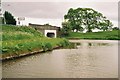
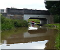
Shropshire Union Canal - Wardle Farm Bridge
The Shropshire Union kinks under the A51 Nantwich Road at Wardle Farm Bridge near Barbridge
Image: © Pierre Terre
Taken: 20 May 2005
0.11 miles
2
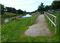
Path up to the A51 Nantwich Road
Next to Wardle Farm Bridge No 102.
Image: © Mat Fascione
Taken: 6 Jul 2019
0.12 miles
3
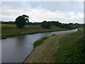
The Shropshire Union at Wardle Farm Bridge
This is part of the Chester Canal, which runs for 19 miles through 14 locks from Nantwich Basin (where it joins the Shropshire Union Canal (Birmingham and Liverpool Junction Canal - Main Line)) to River Dee Branch Junction (where it joins the Shropshire Union Canal (Wirral Line) and the Shropshire Union Canal (Dee Branch)).
Image: © Eirian Evans
Taken: 4 Jul 2010
0.12 miles
4
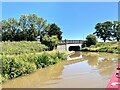
Approaching Wardle Farm Bridge
On the Shropshire Union Canal.
Image: © Andrew Abbott
Taken: 10 Jul 2022
0.15 miles
5
Wardle Farm Bridge No 102
The bridge carries the A51 Nantwich Road across the Shropshire Union Canal.
Image: © Mat Fascione
Taken: 6 Jul 2019
0.15 miles
6
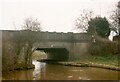
Cheshire Canal
Wardham Farm Bridge, number 102, carries the A51 over the canal.
Image: © Tim Glover
Taken: 6 Apr 1996
0.15 miles
7

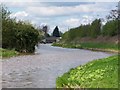
Shropshire Union Canal at Wardle Farm Bridge
Another view of the canal Image], looking east. This is part of the Chester Canal, which runs for 19 miles through 14 locks from Nantwich Basin (where it joins the Shropshire Union Canal (Birmingham and Liverpool Junction Canal - Main Line)) to River Dee Branch Junction (where it joins the Shropshire Union Canal (Wirral Line) and the Shropshire Union Canal (Dee Branch)).
Image: © Eirian Evans
Taken: 4 Jul 2010
0.17 miles
8
Shropshire Union Canal near Wardle Farm Bridge
Bridge 103, Wardle Hall Bridge, is visible in the distance
Image: © David Martin
Taken: 12 Apr 2012
0.18 miles