IMAGES TAKEN NEAR TO
Hospital Street, NANTWICH, CW5 5RJ
Introduction
This page details the photographs taken nearby to Hospital Street, CW5 5RJ by members of the Geograph project.
The Geograph project started in 2005 with the aim of publishing, organising and preserving representative images for every square kilometre of Great Britain, Ireland and the Isle of Man.

There are currently over 7.5m images from over14,400 individuals and you can help contribute to the project by visiting https://www.geograph.org.uk
Image Map
Images are licensed for reuse under creativecommons.org/licenses/by-sa/2.0
Notes
- Clicking on the map will re-center to the selected point.
- The higher the marker number, the further away the image location is from the centre of the postcode.
Image Listing (550 Images Found)
Images are licensed for reuse under creativecommons.org/licenses/by-sa/2.0
Image
Details
Distance
1
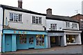
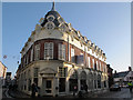
Nantwich: Bizzybods, Wendy's and Mayfair
Image: © Michael Garlick
Taken: 15 May 2018
0.00 miles
2
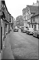
Hospital Street, Nantwich ? 1963
Still part of the A51 through the town, with no restrictions on traffic, although it was part of a one-way scheme. (Through traffic on the A51 could bypass the town centre via Beam Bridge and Millstone Lane.) Even as late as 1963 there was no pavement on the south side of the road.
Image: © Alan Murray-Rust
Taken: 15 Sep 1963
0.01 miles
3
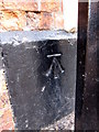
Bench mark on Chatterton House
This bench mark is on the corner of Church Lane and Hospital Street. It probably does not date to the First Geodetic Levelling survey 1851-1858, on the survey line between Newcastle under Lyme and Chester, as it was originally recorded as being on the corner of a house, and the height of this one above ground level is quite a bit higher than the early mark. The modern O.S database has it on the corner of the Lamb Hotel and records suggest that there has been a hotel on this site since the 16th century, and that this 'Lamb Hotel' was only built in 1861, which would be too late for the first survey. The building has now been redeveloped into apartments, shops, and a restaurant - Costa Coffee in 2009. The bench mark is behind the lamppost on the corner, and there is an interesting local website that records some of the recent changes to the building: http://www.dabbersnantwich.me.uk/the_lamb.htm
Image: © John S Turner
Taken: 16 Oct 2009
0.01 miles
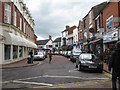
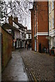
6
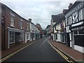
Cobbled street
The yellow lines seem superfluous for so narrow a thoroughfare!
Image: © Ceri Thomas
Taken: 9 Aug 2009
0.01 miles
7
Pillory Street baroque - Nantwich, Cheshire
On the left hand side of this view is 1 - 5 Pillory Street, a Grade II listed building in 17th century French baroque style. It was built in 1911 to a design by P H Edleston of Bower and Edleston, a firm of Nantwich architects, for the grocery company of P H Chesters. Further along Pillory Street are a replica of the old pillory and the Nantwich Museum, housed in the former library which itself was built on the site of a gaol. Time photo taken 11.40 am BST (British Summer Time).
Image: © Martin Richard Phelan
Taken: 4 May 2013
0.02 miles
8
Former Pockets store, Pillory Street, Nantwich
A very distinctive art-nouveau style building of 1911 by E H Edleston, currently vacant. See also Image
Image: © Stephen Craven
Taken: 30 Dec 2016
0.02 miles
9
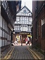
Nantwich: Church Street
A short narrow lane leading south from the church to Hospital Street.
Image: © Christopher Hilton
Taken: 16 Feb 2015
0.02 miles
10
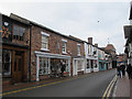
Hospital Street, Nantwich
These shop buildings on the south side of the street look quite historic, especially with one of them suffering obvious subsidence, but unlike many of the town centre buildings they are not listed.
Image: © Stephen Craven
Taken: 30 Dec 2016
0.02 miles