IMAGES TAKEN NEAR TO
The Oaks, Mount Pleasant Residential Park, CREWE, CW4 8LB
Introduction
This page details the photographs taken nearby to The Oaks, Mount Pleasant Residential Park, CW4 8LB by members of the Geograph project.
The Geograph project started in 2005 with the aim of publishing, organising and preserving representative images for every square kilometre of Great Britain, Ireland and the Isle of Man.

There are currently over 7.5m images from over14,400 individuals and you can help contribute to the project by visiting https://www.geograph.org.uk
Image Map
Images are licensed for reuse under creativecommons.org/licenses/by-sa/2.0
Notes
- Clicking on the map will re-center to the selected point.
- The higher the marker number, the further away the image location is from the centre of the postcode.
Image Listing (12 Images Found)
Images are licensed for reuse under creativecommons.org/licenses/by-sa/2.0
Image
Details
Distance

2
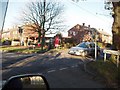
Cross Roads in Goostrey
West of Goostrey centre where Booth Bed Lane & Hermitage Lane meet Main Road
Image: © Ian Warburton
Taken: 25 Nov 2005
0.08 miles
4
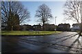
Crossroads at Hermitage Lane
The telephone box on the OS mapping has gone. Several others in the area are retained for defibrillators.
Image: © John M
Taken: 10 Aug 2017
0.10 miles

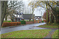
6

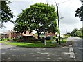
Entrance to Mount Pleasant Residential Park, Goostrey
Image: © Anthony Parkes
Taken: 5 Mar 2014
0.15 miles
8
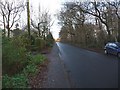
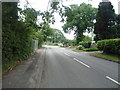
Looking along New Platt Lane towards Goostrey Lane
Image: © Christine Johnstone
Taken: 6 Dec 2009
0.22 miles
9
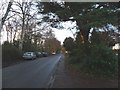
Looking along New Platt Lane away from Goostrey Lane
Image: © Christine Johnstone
Taken: 6 Dec 2009
0.23 miles
10
Boothbed Lane, Goostrey
A variety of different house styles line Boothbed Lane here to the north of its junction with Sandy Lane.
Image: © Stephen McKay
Taken: 27 Nov 2019
0.23 miles