IMAGES TAKEN NEAR TO
Capesthorne Close, CREWE, CW4 7EN
Introduction
This page details the photographs taken nearby to Capesthorne Close, CW4 7EN by members of the Geograph project.
The Geograph project started in 2005 with the aim of publishing, organising and preserving representative images for every square kilometre of Great Britain, Ireland and the Isle of Man.

There are currently over 7.5m images from over14,400 individuals and you can help contribute to the project by visiting https://www.geograph.org.uk
Image Map
Images are licensed for reuse under creativecommons.org/licenses/by-sa/2.0
Notes
- Clicking on the map will re-center to the selected point.
- The higher the marker number, the further away the image location is from the centre of the postcode.
Image Listing (34 Images Found)
Images are licensed for reuse under creativecommons.org/licenses/by-sa/2.0
Image
Details
Distance
1
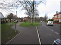
B5308 Middlewich Road/Brookfield Drive junction Holmes Chapel
Image: © Peter Turner
Taken: 21 Feb 2012
0.04 miles
2
Path from Sadlers Close into Moreton Drive
It's not clear whether the estate was built like this, with two roads almost end-to-end and a short path connecting them, or whether a through road has been closed to motor traffic to prevent rat running.
Image: © Stephen Craven
Taken: 23 Feb 2019
0.06 miles
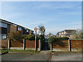
3
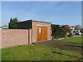
Substation on Moreton Drive
A larger installation than most of those found on housing estates.
Image: © Stephen Craven
Taken: 23 Feb 2019
0.07 miles
5
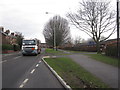
B5308 Middlewich Road, Holmes Chapel
Leading to the M6 junction from Holmes Chapel centre this B-road carries a heavy load of traffic and with no special restrictions outside the primary school here.
Image: © Peter Turner
Taken: 21 Feb 2012
0.13 miles
6
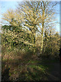
Alder catkins
I believe this is an alder tree, loaded with catkins, but stand to be corrected as to species.
Image: © Stephen Craven
Taken: 23 Feb 2019
0.13 miles
7
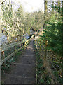
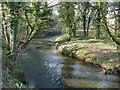
Steps down to the river
This footpath leads down to the bank of the river Dane and forms part of the Dane Valley Way.
Image: © Stephen Craven
Taken: 23 Feb 2019
0.13 miles
9
Bend in the river Dane
The Dane is quite meandering in this stretch, and at this point performs a bend of about 120 degrees around the peninsula occupied by Massey Feeds.
Image: © Stephen Craven
Taken: 23 Feb 2019
0.14 miles
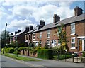
10
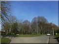
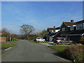
Junction of Westmorland Terrace and Sadlers Close
The trees in the background mark the top of the steep slope into the Dane Valley.
Image: © Stephen Craven
Taken: 23 Feb 2019
0.14 miles