IMAGES TAKEN NEAR TO
The Green, CREWE, CW3 0BB
Introduction
This page details the photographs taken nearby to The Green, CW3 0BB by members of the Geograph project.
The Geograph project started in 2005 with the aim of publishing, organising and preserving representative images for every square kilometre of Great Britain, Ireland and the Isle of Man.

There are currently over 7.5m images from over14,400 individuals and you can help contribute to the project by visiting https://www.geograph.org.uk
Image Map
Images are licensed for reuse under creativecommons.org/licenses/by-sa/2.0
Notes
- Clicking on the map will re-center to the selected point.
- The higher the marker number, the further away the image location is from the centre of the postcode.
Image Listing (211 Images Found)
Images are licensed for reuse under creativecommons.org/licenses/by-sa/2.0
Image
Details
Distance
1
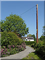
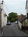
Vicarage Lane in Audlem, Cheshire
This is Vicarage Lane, looking north-east towards the junction with School Lane.
Image: © Roger Kidd
Taken: 7 Jun 2018
0.01 miles
2
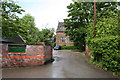
Audlem Country Nursing Home
Housed in the Old Grammar School, built 1625-5.
Image: © Dave Dunford
Taken: 17 May 2009
0.02 miles
3
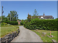
Vicarage Lane in Audlem, Cheshire
This is Vicarage Lane, looking north towards the junction with School Lane.
Image: © Roger Kidd
Taken: 7 Jun 2018
0.03 miles
4
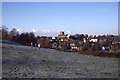
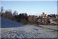
Audlem from Holmes Bank, Christmas Day 1995
The steep rise to the south of Audlem Brook, and the plateau beyond it, are known as Holmes Bank; when there is snow, this is the main sledging location in the village.
Image: © Christopher Hilton
Taken: 25 Dec 1995
0.03 miles
5
Audlem from Holmes Bank, Christmas Day 1995
The steep rise to the south of Audlem Brook, and the plateau beyond it, are known as Holmes Bank; when there is snow, this is the main sledging location in the village.
Image: © Christopher Hilton
Taken: 25 Dec 1995
0.03 miles
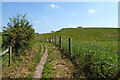
6
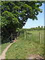
Footpath to Audlem in Cheshire
Looking north-east and close to Audlem, a popular public footpath through fields and meadows links Copthorne with the village, crossing the Shropshire Union Canal at Lock No 11.
Image: © Roger Kidd
Taken: 7 Jun 2018
0.04 miles
8
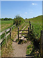
Footpath to Sandy Lane near Audlem
Looking south-east from near Vicarage Lane in Audlem.
Image: © Roger Kidd
Taken: 7 Jun 2018
0.05 miles
9
Footpath to Sandy Lane near Audlem
Looking south-east from near Vicarage Lane in Audlem.
Image: © Roger Kidd
Taken: 7 Jun 2018
0.05 miles
10
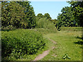
Footpath through meadows by Audlem, Cheshire
Looking north and approaching Audlem, a popular public footpath through fields and meadows links Copthorne with Audlem, crossing the Shropshire Union Canal at Lock No 11. About a hundred metres ahead the footpath enters the village via Vicarage Lane.
Image: © Roger Kidd
Taken: 7 Jun 2018
0.06 miles