IMAGES TAKEN NEAR TO
Bowen Street, CREWE, CW2 7RU
Introduction
This page details the photographs taken nearby to Bowen Street, CW2 7RU by members of the Geograph project.
The Geograph project started in 2005 with the aim of publishing, organising and preserving representative images for every square kilometre of Great Britain, Ireland and the Isle of Man.

There are currently over 7.5m images from over14,400 individuals and you can help contribute to the project by visiting https://www.geograph.org.uk
Image Map
Images are licensed for reuse under creativecommons.org/licenses/by-sa/2.0
Notes
- Clicking on the map will re-center to the selected point.
- The higher the marker number, the further away the image location is from the centre of the postcode.
Image Listing (20 Images Found)
Images are licensed for reuse under creativecommons.org/licenses/by-sa/2.0
Image
Details
Distance
1
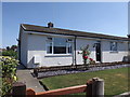
Prefabricated Bungalow
This bungalow shows how the majority of this estate looks now having been clad with insulation though some have been coated in brick.
Image: © Garry Lavender-Rimmer
Taken: 5 Aug 2018
0.09 miles
2
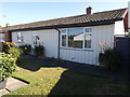
Prefabricated Bungalow
This is one "prefab" of only 2 or 3 on an estate of approx 70 bungalows that are almost original in appearance.
This property is privately owned.
These prefabs were built to house servicemen returning home from World War 2 and had a life expectancy of 15 to 20 years but are now over 60 years old.
Image: © Garry Lavender-Rimmer
Taken: 5 Aug 2018
0.10 miles
4
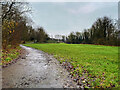
Public Footpath
Photograph taken from Doddington road showing the footpath known locally as both "The Black path" and "The Ravine"
Image: © Garry Lavender-Rimmer
Taken: 28 May 2015
0.18 miles
5
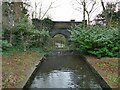
Queen's Park - lake outfall
The park lake was formed from damming the Valley Brook; the outfall drops over a weir, and resumes its course as it flows under Queen's Park Drive.
Image: © Stephen Craven
Taken: 30 Dec 2022
0.19 miles
6
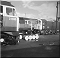
Crewe locomotive works
Two class 47 diesels and a class 74 electro-diesel outside Crewe works.
The class 74 (E6102) had just been rebuilt from a conventional electric loco, by the addition of a diesel-generator and push-pull controls. These locos were converted for the Waterloo - Bournemouth electrification scheme, and were intended for use on Southampton boat trains. The diesel engine enabled them to run on unelectified lines at reduced power. However, they only survived for about another 10 years.
I don't know the grid reference for this photo, or even whether this part of the works still survives.
Image: © Ian Taylor
Taken: 15 Oct 1967
0.20 miles
7
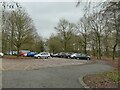
Queen's Park - the car park
A view into the car park, most of which is in the next grid square from the park itself.
Image: © Stephen Craven
Taken: 30 Dec 2022
0.20 miles
8

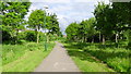
Public Footpath
Photograph taken from Alton street showing the footpath known locally as both "The Black Path" or "The Ravine"
Image: © Garry Lavender-Rimmer
Taken: 26 May 2015
0.20 miles
9
Entrance Gates, Queen's Park
Queen's Park, Crewe, was dedicated in July 1887 to mark the joint occasion of Queen Victoria’s Golden Jubilee and the fiftieth anniversary of the opening of the Grand Junction Railway. The park, a gift to the town by the London & North Western Railway Co, was officially opened to the public in June 1888. It is listed as Grade II* on the National Heritage List of Parks and Gardens for England.
Image: © David Dixon
Taken: 28 Dec 2024
0.22 miles
10
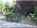
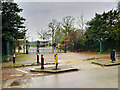
Queen's Park: cycle parking
An unusual design of cycle stand near the eastern gates to the park Image The park forms part of a signed cycle route between Crewe town centre and Nantwich.
Image: © Stephen Craven
Taken: 19 Jul 2015
0.22 miles