IMAGES TAKEN NEAR TO
Thornton Drive, CREWE, CW2 6RN
Introduction
This page details the photographs taken nearby to Thornton Drive, CW2 6RN by members of the Geograph project.
The Geograph project started in 2005 with the aim of publishing, organising and preserving representative images for every square kilometre of Great Britain, Ireland and the Isle of Man.

There are currently over 7.5m images from over14,400 individuals and you can help contribute to the project by visiting https://www.geograph.org.uk
Image Map (14 Images)


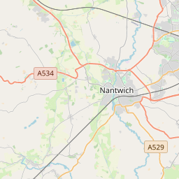
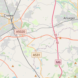

Leaflet Map data © OpenStreetMap
Images are licensed for reuse under creativecommons.org/licenses/by-sa/2.0
Notes
- Clicking on the map will re-center to the selected point.
- The higher the marker number, the further away the image location is from the centre of the postcode.
Image Listing (14 Images Found)
Images are licensed for reuse under creativecommons.org/licenses/by-sa/2.0
Image
Details
Distance
1
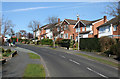
Bankfield Avenue, Wistaston
Bankfield Avenue slopes down from Rope Bank Avenue to the valley of Swill Brook. Lined with orange-brick detached houses dating from the late 20th century, typical of much of the grid square, it's a popular venue for dog walkers
Image: © Espresso Addict
Taken: 21 Mar 2007
0.07 miles
2
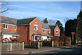
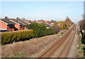
Detached houses, Rope Lane, Wistaston
Modern, red-brick detached houses on Rope Lane near Ropegreen Bridge, on the south-western edge of Wistaston. The railway line runs beyond the trees on the right
Image: © Espresso Addict
Taken: 21 Mar 2007
0.08 miles
3
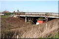
View NE from Ropegreen Bridge
View north east from the Ropegreen railway bridge, showing the modern red-brick housing estates making up Wistaston (left). Image is just visible in the distance (right, by railway)
Image: © Espresso Addict
Taken: 21 Mar 2007
0.09 miles
4
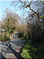
Springtime on Gresty Lane
Gresty Lane descends from the railway embankment at Ropegreen Bridge towards the valley of Swill Brook; the yellow-and-black warning signs mark the bridge over the brook. A garden centre adjacent to the railway lies on the left. Celandines can be seen in the verge in the foreground
Image: © Espresso Addict
Taken: 21 Mar 2007
0.13 miles
5
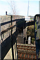
Ropegreen Bridge
The brown-brick railway bridge has a single carriageway, controlled by traffic lights. A young birch is growing out of the brickwork. A concrete pedestrian bridge runs to the south west (right); see Image
Image: © Espresso Addict
Taken: 21 Mar 2007
0.14 miles
6

Swill Brook
A placid tributary of Valley Brook. View south east, from the bridge on Gresty Lane near Brook Farm, just after the brook has passed under the railway line
Image: © Espresso Addict
Taken: 21 Mar 2007
0.15 miles
7
Pedestrian bridge by Ropegreen Bridge
View of Image from the south west (on Eastern Road), showing the concrete pedestrian bridge, as well as a pipe crossing the railway
Image: © Espresso Addict
Taken: 21 Mar 2007
0.15 miles
8
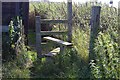
Fashions come and go but stile...
This is the stile for the Public Footpath by Rope Lane Railway Bridge.
Image: © Terry Hughes
Taken: 31 Jul 2009
0.16 miles
9
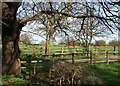
Oak by Brook Farm track
The track to Brook Farm is lined with young trees, but a mature oak stands on Gresty Road by the entrance (left). A group of geese can just be seen in the pasture (centre)
Image: © Espresso Addict
Taken: 21 Mar 2007
0.16 miles
10
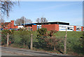
Berkeley Primary School, Wistaston
Single-storey, red-brick primary school on Laidon Avenue, set in playing fields near the railway line
Image: © Espresso Addict
Taken: 21 Mar 2007
0.16 miles