IMAGES TAKEN NEAR TO
Marshfern Place, CREWE, CW2 5TT
Introduction
This page details the photographs taken nearby to Marshfern Place, CW2 5TT by members of the Geograph project.
The Geograph project started in 2005 with the aim of publishing, organising and preserving representative images for every square kilometre of Great Britain, Ireland and the Isle of Man.

There are currently over 7.5m images from over14,400 individuals and you can help contribute to the project by visiting https://www.geograph.org.uk
Image Map
Images are licensed for reuse under creativecommons.org/licenses/by-sa/2.0
Notes
- Clicking on the map will re-center to the selected point.
- The higher the marker number, the further away the image location is from the centre of the postcode.
Image Listing (5 Images Found)
Images are licensed for reuse under creativecommons.org/licenses/by-sa/2.0
Image
Details
Distance
2
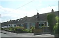
Bungalows on Stock Lane, Wybunbury
A continuous ribbon of housing northwards links these bungalows to Shavington, but officially - presumably as a result of the parish boundary - these houses south of the former main A52 lie in Wybunbury.
Image: © Christopher Hilton
Taken: 3 Jun 2016
0.12 miles
3
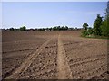
Farmland soon to be a building site
Farmland off the Newcastle Road, Shavington soon to be built on.
Another Greenfield site land lost to builders instead of using a Brownfield site.
Image: © Garry Lavender-Rimmer
Taken: 4 Jul 2015
0.13 miles
4
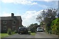
Cottages and driveways on Stock Lane, Wybunbury
The horsebox seen behind the gate on the left is an indication of the agricultural buildings that lie beyond that gate. On the right-hand driveway, a car-port marks a more modern house.
A continuous ribbon of housing northwards links these bungalows to Shavington, but officially - presumably as a result of the parish boundary - these houses south of the former main A52 lie in Wybunbury.
Image: © Christopher Hilton
Taken: 3 Jun 2016
0.20 miles
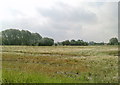
5
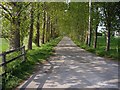
Lane by Cockshades Farm
This lane is at the end of a footpath between Wynbunbury and Shavington, it leads onto Stock Lane
Image: © Ian Bottomley
Taken: 28 Apr 2007
0.22 miles