IMAGES TAKEN NEAR TO
Dial Lane, CONGLETON, CW12 3QJ
Introduction
This page details the photographs taken nearby to Dial Lane, CW12 3QJ by members of the Geograph project.
The Geograph project started in 2005 with the aim of publishing, organising and preserving representative images for every square kilometre of Great Britain, Ireland and the Isle of Man.

There are currently over 7.5m images from over14,400 individuals and you can help contribute to the project by visiting https://www.geograph.org.uk
Image Map
Images are licensed for reuse under creativecommons.org/licenses/by-sa/2.0
Notes
- Clicking on the map will re-center to the selected point.
- The higher the marker number, the further away the image location is from the centre of the postcode.
Image Listing (13 Images Found)
Images are licensed for reuse under creativecommons.org/licenses/by-sa/2.0
Image
Details
Distance
1
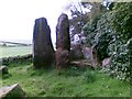
The Bridestones
An ancient burial chamber.
Image: © John Harrison
Taken: 5 May 2012
0.04 miles
2
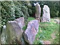
The Bridestones
These stones are right on the boundary between Cheshire and Staffordshire.
Image: © John Harrison
Taken: 5 May 2012
0.04 miles
3
The Bridestones
The wall in front of the stones is the county boundary between Cheshire and Staffordshire.
Image: © John Harrison
Taken: 5 May 2012
0.05 miles
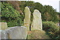
5
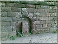
Boundary stone next to The Bridestones
This boundary stone (BS on the map) in the lane to the farm is set in an arch in the wall. It marks the boundary between Cheshire and Staffordshire. It has a cross carved on top and a large letter 'B'.
Image: © John Harrison
Taken: 5 May 2012
0.06 miles
6
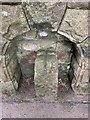
Old Boundary Marker
Parish Boundary Marker in a recess in a stone wall beside the drive to the Bridestones off Dial Lane. On the boundary of Biddulph and Rushton parishes, Staffordshire and Congleton parish, Cheshire. Inscribed B on its centre face with a cross cut into its top. For older photos see https://www.geograph.org.uk/photo/6043452 and https://www.geograph.org.uk/photo/2934853.
Milestone Society National ID: ST_BIDD01pb
Image: © W MacDonald
Taken: 4 Jul 2020
0.06 miles
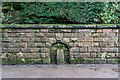
7
Old Boundary Marker near Bridestones, Biddulph Parish
Parish Boundary Marker in parish of Biddulph (Staffordshire Moorlands District), by drive to Bridestones, off Dial Lane, in recess in stone wall.
To be surveyed
Milestone Society National ID: ST_BIDD01pb
Image: © Milestone Society
Taken: Unknown
0.06 miles
8

The Bridestones Burial Chamber, Congleton
The Bridestones is a chambered cairn, near Congleton, Cheshire, England, that was constructed in the Neolithic period about 3500–2400 BC,
https://en.wikipedia.org/wiki/The_Bridestones
Image: © Brian Deegan
Taken: 14 Mar 2021
0.06 miles
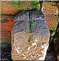
9
Boundary Marker Stone (Staffordshire/Cheshire), Bridestone
Image: © Brian Deegan
Taken: 14 Mar 2021
0.07 miles
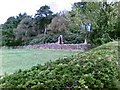
10

Down Dial Lane past The Bridestones lies Congleton some 3miles away
Image: © Peter Turner
Taken: 24 Jan 2013
0.15 miles