IMAGES TAKEN NEAR TO
North Street, CONGLETON, CW12 1HF
Introduction
This page details the photographs taken nearby to North Street, CW12 1HF by members of the Geograph project.
The Geograph project started in 2005 with the aim of publishing, organising and preserving representative images for every square kilometre of Great Britain, Ireland and the Isle of Man.

There are currently over 7.5m images from over14,400 individuals and you can help contribute to the project by visiting https://www.geograph.org.uk
Image Map
Images are licensed for reuse under creativecommons.org/licenses/by-sa/2.0
Notes
- Clicking on the map will re-center to the selected point.
- The higher the marker number, the further away the image location is from the centre of the postcode.
Image Listing (124 Images Found)
Images are licensed for reuse under creativecommons.org/licenses/by-sa/2.0
Image
Details
Distance
1
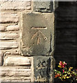
Filled-in bench mark
It looks as if this bench mark, on Image on Antrobus Street, was carefully filled with cement after finishing. There is no record of this cut mark on the Ordnance Survey database but there is a bench mark shown here on the 1909 map with a height of 295.84 ft (90.17m) above sea level. For more details on this and other nearby bench marks see http://www.bench-marks.org.uk/bm37368 .
Image: © Jonathan Kington
Taken: 13 Mar 2011
0.04 miles
2
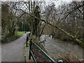
Path by the River Dane in Congleton
Image: © Jonathan Hutchins
Taken: 20 Jan 2019
0.05 miles
3
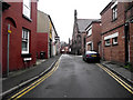
Cross Street
Looking along Cross Street from its junction with Mill Street, the Image is about halfway along on the right.
Image: © Jonathan Kington
Taken: 20 Mar 2011
0.05 miles
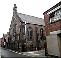
4
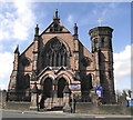
The United Reformed Church
The original church was built in 1790 and was located on Mill Street, where the Image now stands, it was rebuilt and replaced by this building on Antrobus Street in 1876. There is what appears to be a filled in bench mark at the base of the buttress adjoining the tower (Image).
Image: © Jonathan Kington
Taken: 13 Mar 2011
0.05 miles
5
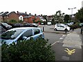
Antrobus Street car park, Congleton
A relatively cheap pay-and-display facility, handy for the town centre shops.
Image: © Stephen Craven
Taken: 14 Aug 2021
0.06 miles
6
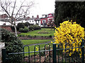
Small park on Antrobus Street
This lovely little formal garden appears to be open to the public.
Image: © Jonathan Kington
Taken: 20 Mar 2011
0.06 miles
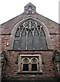
7
Pentecostal Chapel
This lovely building on Cross Street was built in 1883 using stone pink sandstone from Teggs Nose Quarry near Macclesfield. For a picture of the front see Image
Image: © Jonathan Kington
Taken: 20 Mar 2011
0.07 miles
8
Front of the chapel
The Pentecostal Chapel was built in 1883 using pink sandstone from Teggs Nose Quarry near Macclesfield. Cross Street is very narrow making it difficult to get a shot of the full front. (See also Image).
Image: © Jonathan Kington
Taken: 20 Mar 2011
0.07 miles
9
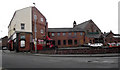
Bon-O-Phool
Located on the corner of Mill Street and Antrobus Street, Bon-O-Phool is an Indian restaurant and take-away. The rear of the Image on Cross Street is visible too.
Image: © Jonathan Kington
Taken: 20 Mar 2011
0.08 miles
10
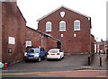
Masonic Hall
Built in 1878, the Masonic Hall is located on Mill Street. The front entrance is just in front of the white car, near the bottom of the brickwork and just to the right of that car is an Ordnance Survey flush bracket (Image). This was also the site of the original United Reformed Church before it was moved to Antrobus Street (Image).
Image: © Jonathan Kington
Taken: 15 Dec 2010
0.09 miles