IMAGES TAKEN NEAR TO
Hassall Road, SANDBACH, CW11 4XJ
Introduction
This page details the photographs taken nearby to Hassall Road, CW11 4XJ by members of the Geograph project.
The Geograph project started in 2005 with the aim of publishing, organising and preserving representative images for every square kilometre of Great Britain, Ireland and the Isle of Man.

There are currently over 7.5m images from over14,400 individuals and you can help contribute to the project by visiting https://www.geograph.org.uk
Image Map
Images are licensed for reuse under creativecommons.org/licenses/by-sa/2.0
Notes
- Clicking on the map will re-center to the selected point.
- The higher the marker number, the further away the image location is from the centre of the postcode.
Image Listing (63 Images Found)
Images are licensed for reuse under creativecommons.org/licenses/by-sa/2.0
Image
Details
Distance
1
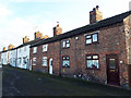
Houses on Betchton Road at Malkin's Bank
Some of the houses have been whitewashed, others remain plain red brick.
Image: © Stephen Craven
Taken: 10 Nov 2019
0.05 miles
2
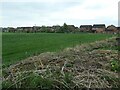
New housing, Boulton's Close
This small development almost doubled the size of the village of Malkin's Bank.
Image: © Christine Johnstone
Taken: 30 Apr 2023
0.06 miles
3

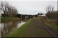
Bridge and Lock No 63 at Malkin's Bank, Cheshire
This half of the paired locks and bridge at Malkin's Bank was built in the 1830s, around sixty years after the original constructions (off to the right). All of it is Grade II listed.
This is the northern of the two lock chambers. The narrowboat "Vale" is a hire boat from the Anglo-Welsh fleet and will continue westwards towards Middlewich.
The other (c1775) lock is not in use currently.
Image]
Image]
Image: © Roger D Kidd
Taken: 31 Aug 2011
0.06 miles
4
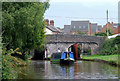
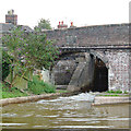
Paired Locks at Malkin's Bank, Cheshire
This is paired Lock No 63.
The right (south) lock is not currently in use.
The Locks are Grade II listed as a group with the bridge (No 151). The south side is circa 1776, (James Brindley),and north side (on the left) is from the 1830s, (consultant Thomas Telford). Looking at the bridge brickwork it is difficult to spot the join considering the northern half was built nearly sixty years later then the original.
The eight paired locks forming the Wheelock Flight allows a rise in water level of 79ft 6in (24·2 metres). This is the fourth pair up. The flight is also part of the more extended series of twenty-six locks, many also paired, which make up the Cheshire Locks, or "Heartbreak Hill" as the canal climbs towards Kidsgrove and the Harecastle Tunnel. The pairing of nearly all the locks was done circa 1830 to speed the traffic.
Image: © Roger D Kidd
Taken: 31 Aug 2011
0.06 miles
5
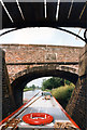
Trent & Mersey Canal from Lock 63 through Malkins Bridge 151
Image: © Jo and Steve Turner
Taken: 17 Jun 1997
0.06 miles
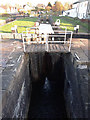
7
Bridge and Lock No 63 at Malkin's Bank, Cheshire
This half of the paired locks and bridge at Malkin's Bank was built in the 1830s, around sixty years after the original constructions (off to the right). All of it is Grade II listed.
This is the northern of the two lock chambers, and it is being emptied to allow a narrowboat passage westwards towards Middlewich. The other (c1775) lock is not in use currently.
Image]
Image]
Image: © Roger D Kidd
Taken: 31 Aug 2011
0.06 miles
8
The old chapel, Betchton Road at Malkin's Bank
The chapel is not shown on the 1909 OS map but does appear by 1947. I haven't established which denomination it was, but the Methodists had a chapel further along the road. Now in residential use.
Image: © Stephen Craven
Taken: 10 Nov 2019
0.06 miles
9
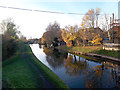
Trent and Mersey Canal west of Malkin's Bank
There is a winding hole (canal widening) concealed among the tree on the right bank.
Image: © Stephen Craven
Taken: 10 Nov 2019
0.06 miles
10
Trent and Mersey Canal lock 63 (Malkin's Bank), detail
This is the earlier of the two parallel locks, being James Brindley's earlier work of c.1775. Together they are listed grade II (list entry 1074927).
Image: © Stephen Craven
Taken: 10 Nov 2019
0.07 miles