IMAGES TAKEN NEAR TO
Pine Grove, SANDBACH, CW11 4JJ
Introduction
This page details the photographs taken nearby to Pine Grove, CW11 4JJ by members of the Geograph project.
The Geograph project started in 2005 with the aim of publishing, organising and preserving representative images for every square kilometre of Great Britain, Ireland and the Isle of Man.

There are currently over 7.5m images from over14,400 individuals and you can help contribute to the project by visiting https://www.geograph.org.uk
Image Map
Images are licensed for reuse under creativecommons.org/licenses/by-sa/2.0
Notes
- Clicking on the map will re-center to the selected point.
- The higher the marker number, the further away the image location is from the centre of the postcode.
Image Listing (82 Images Found)
Images are licensed for reuse under creativecommons.org/licenses/by-sa/2.0
Image
Details
Distance
1
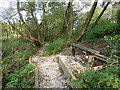
Dingle Wood: Path alongside the Sandbach bypass
Part of a new path opened (according to some other walkers) about 3 years earlier.
Image: © Stephen Craven
Taken: 14 Oct 2017
0.10 miles
2
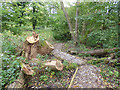
Dingle Wood: felled tree
The tree has not been completely removed, but all its major limbs have had to be cut back to make room for a footpath.
Image: © Stephen Craven
Taken: 14 Oct 2017
0.11 miles
3
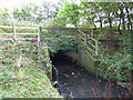
Arclid Brook below the Sandbach bypass
The brook is culverted under the A534.
Image: © Stephen Craven
Taken: 14 Oct 2017
0.11 miles
4
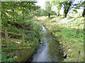
Arclid Brook below the Sandbach bypass
The flow in the brook is effectively regulated by the flooded gravel pit a couple of miles further upstream through which it now flows.
Image: © Stephen Craven
Taken: 14 Oct 2017
0.12 miles
5
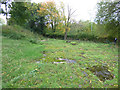
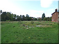
Site of the former Sandbach waterworks (1)
Old maps show this area as a waterworks, opened in 1891. By 2014 it was derelict and planning permission (Ref 12/1650C) was granted for its demolition, removal of water treatment storage and settlement tanks, and construction of 12 two-storey detached dwellings. However, three years later development was yet to commence - developers seem at present to be focussing on areas closer to the motorway junction and railway station. See also Image
Image: © Stephen Craven
Taken: 14 Oct 2017
0.13 miles
6
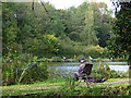
Dingle Lake from the south bank
The new path on this side of the brook gives a different perspective on the fishing lake. See Image for a view from the opposite bank.
Image: © Stephen Craven
Taken: 14 Oct 2017
0.14 miles
7
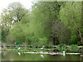
Dingle Lake (2)
A heron stands on one of the (artificial?) islands in the lake.
Image: © Stephen Craven
Taken: 1 May 2010
0.14 miles
8
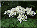
Bee on a hogweed flower
Alongside the path through Dingle Wood.
Image: © Stephen Craven
Taken: 14 Oct 2017
0.14 miles
9
Site of the former Sandbach waterworks (2)
Old maps show this area as a waterworks, opened in 1891. By 2014 it was derelict and planning permission (Ref 12/1650C) was granted for its demolition, removal of water treatment storage and settlement tanks, and construction of 12 two-storey detached dwellings. However, three years later development was yet to commence - developers seem at present to be focussing on areas closer to the motorway junction and railway station. The building at the right of the photo was the water board offices Image
Image: © Stephen Craven
Taken: 14 Oct 2017
0.15 miles
10
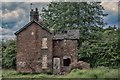
Waterworks House Dingle Lane Sandbach
Old maps show this area as a waterworks; both the water (abstraction) works here, and the sewage works further downstream, were opened in 1891 at the same time that the Dingle fishing lake was formed.
Image: © paul sandham
Taken: 14 Jun 2017
0.15 miles