IMAGES TAKEN NEAR TO
Mill Pool Way, SANDBACH, CW11 4BS
Introduction
This page details the photographs taken nearby to Mill Pool Way, CW11 4BS by members of the Geograph project.
The Geograph project started in 2005 with the aim of publishing, organising and preserving representative images for every square kilometre of Great Britain, Ireland and the Isle of Man.

There are currently over 7.5m images from over14,400 individuals and you can help contribute to the project by visiting https://www.geograph.org.uk
Image Map
Images are licensed for reuse under creativecommons.org/licenses/by-sa/2.0
Notes
- Clicking on the map will re-center to the selected point.
- The higher the marker number, the further away the image location is from the centre of the postcode.
Image Listing (196 Images Found)
Images are licensed for reuse under creativecommons.org/licenses/by-sa/2.0
Image
Details
Distance
1
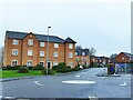
Millpool Way, Sandbach
A fairly recent housing development behind the B&M store and on the site of the former town gas works, linking to Newall Avenue (an older area of housing off Crewe Road).
Image: © Stephen Craven
Taken: 28 Dec 2021
0.04 miles
2
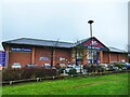
B&M, Old Mill Road, Sandbach
The store was built on the 'far' side of the bypass and was previously Homebase DIY.
Image: © Stephen Craven
Taken: 28 Dec 2021
0.05 miles
3
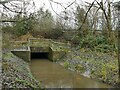
Culvert on the Dingle Brook
The culvert carries the brook under the A534 Wheelock Bypass.
Image: © Stephen Craven
Taken: 28 Dec 2021
0.08 miles
4
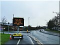
Covid-19 sign, Old Mill Road, Sandbach
This message would have meant nothing before late 2021, but the Omicron variant of the Covid-19 virus was spreading rapidly through England by December. The solar-powered sign encouraged people to get a third dose of vaccine (colloquially a 'booster jab').
The road is named after a former silk mill at its southern end, no trace of which now remains.
Image: © Stephen Craven
Taken: 28 Dec 2021
0.08 miles

6
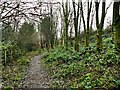
Northern end of the Brook Wood Trail
The trail runs through woodland for about 750m from Old Mill Road to Coronation Crescent.
Image: © Stephen Craven
Taken: 28 Dec 2021
0.09 miles
7
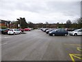
Sandbach, car park
Next to the ring road. Free!
Image: © Mike Faherty
Taken: 28 Dec 2012
0.09 miles
8
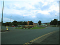
Roundabout on Sandbach Bypass
This is where the Sandbach bypass (foreground) meets the inner relief road (right, where the car with headlights is emerging) and becomes the Wheelock Bypass (far left).
Image: © Stephen Craven
Taken: 21 Jul 2012
0.10 miles
9
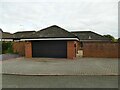
Der Alte Schlachthof, Flat Lane, Sandbach
The German name of this modern property means 'The old slaughterhouse'. My sister recalls the abattoir still operating in the early 1980s, but Stewart Green's online history site records its demolition in June 1987.
Image: © Stephen Craven
Taken: 31 Mar 2024
0.10 miles
10
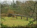
Sewer across the Dingle Brook
Shown just as 'pipeline' on large scale maps, this is undoubtedly a sewer, as there used to be a sewage works just south of this location, marked on the 1930s map but already shown as disused by the 1960s. The pipe now runs through the embankment of the A534 Wheelock Bypass, presumably to a pumping station somewhere the other side.
Image: © Stephen Craven
Taken: 28 Dec 2021
0.11 miles