IMAGES TAKEN NEAR TO
Newcastle Road South, SANDBACH, CW11 1RJ
Introduction
This page details the photographs taken nearby to Newcastle Road South, CW11 1RJ by members of the Geograph project.
The Geograph project started in 2005 with the aim of publishing, organising and preserving representative images for every square kilometre of Great Britain, Ireland and the Isle of Man.

There are currently over 7.5m images from over14,400 individuals and you can help contribute to the project by visiting https://www.geograph.org.uk
Image Map
Images are licensed for reuse under creativecommons.org/licenses/by-sa/2.0
Notes
- Clicking on the map will re-center to the selected point.
- The higher the marker number, the further away the image location is from the centre of the postcode.
Image Listing (28 Images Found)
Images are licensed for reuse under creativecommons.org/licenses/by-sa/2.0
Image
Details
Distance
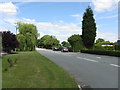
1
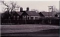
A50 at Brereton Green
Effectively a bypass for the village.
Image: © Peter Whatley
Taken: 15 Jun 2010
0.02 miles
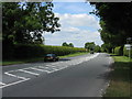
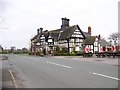
2
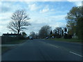
Brereton Green - the old main road
Now labelled Newcastle Road South. The new main road is a few dozen yards to the left.
Image: © Peter Whatley
Taken: 15 Jun 2010
0.04 miles
3
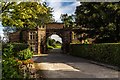
Brereton Hall
Lodge at the entrance to Brereton Hall.
Image: © Peter McDermott
Taken: 28 Aug 2017
0.07 miles
4
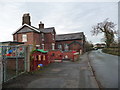
The school in School Lane
Brereton C of E primary school must have been built in the late 1800s [as a school and the teacher's house]. It currently has 181 pupils.
Image: © Christine Johnstone
Taken: 15 Dec 2013
0.08 miles
5
Brereton Playground and Primary School
A view of the playground at Brereton Green with the Primary School in the background
Image: © Paul Gould
Taken: 28 Dec 1997
0.08 miles
6
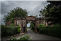
Lodge Entrance for Brereton Hall.
The lodge is built 1830 in sandstone and consists of a Tudor archway flanked by octagonal turrets, each with a lean-to wing. The turrets are crenelated and in two storeys. There are mullioned and transomed windows in both storeys at the front and the back. In the canted inner faces of each of the turrets is a doorway and a cross-shaped arrow loop above it.
https://en.wikipedia.org/wiki/Brereton_Hall
Image: © Brian Deegan
Taken: 22 Aug 2020
0.08 miles
8
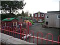
Playground, south side of Brereton Primary School
Well-equipped, but perhaps for infants rather than juniors?
Image: © Christine Johnstone
Taken: 15 Dec 2013
0.09 miles
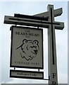
10
The Bears Head, Brereton Green
http://www.bedandbreakfastdirect.co.uk/show_cotdetails.asp?cid=935 says "The Bear's Head was built in 1615 according to the date carved into the old timbered porch and has been described as being "as noble as many an old manor house" by one commentator. In the days of coach travel nearby Brereton was a thriving village of 700 inhabitants and this inn was a popular posting house on the London-Liverpool route.
As coaching declined the Bear's Head entered a quieter period and by the 1891 survey of Cheshire public houses it was recorded as a freehouse. It then had 4 bedrooms and "drinking accommodation for 12 persons", with 2 stables and 6 stalls. However, trade must have recovered by the turn of the century since in 1903 facilities were extended to accommodate 6 bedrooms, 4 stables and 13 stalls."
Image: © Elliott Simpson
Taken: 4 Apr 2008
0.11 miles