IMAGES TAKEN NEAR TO
Ashbourne Square, ATHERSTONE, CV9 2SD
Introduction
This page details the photographs taken nearby to Ashbourne Square, CV9 2SD by members of the Geograph project.
The Geograph project started in 2005 with the aim of publishing, organising and preserving representative images for every square kilometre of Great Britain, Ireland and the Isle of Man.

There are currently over 7.5m images from over14,400 individuals and you can help contribute to the project by visiting https://www.geograph.org.uk
Image Map
Images are licensed for reuse under creativecommons.org/licenses/by-sa/2.0
Notes
- Clicking on the map will re-center to the selected point.
- The higher the marker number, the further away the image location is from the centre of the postcode.
Image Listing (4 Images Found)
Images are licensed for reuse under creativecommons.org/licenses/by-sa/2.0
Image
Details
Distance
1
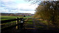
View north from Boulters Lane
Woodland to the right is Cope's Rough.
The long view includes a large mining spoil hill overlooking a large industrial development site adjacent to Junction 10 of the M42.
Image: © Jonathan Billinger
Taken: 7 Feb 2017
0.12 miles
2
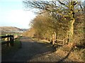
Track by the side of Biddle's Wood
The Get-a-Map 1:25000 doesn't name this wood (on the right), but on my old map it is called Biddle's Wood. In the distance can be seen new development and behind that a man-made hill caused by old mine workings. This area is riddled with old mine shafts and mining used to be a big employer in the area. Now there is only one mine left anywhere near (to my knowledge) and that's the supermine at Daw Mill some miles away towards Coventry.
Image: © Rob Farrow
Taken: 21 Jan 2006
0.13 miles
4
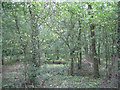
South end of Cope's Rough
This northern part of the wood, contains a brook that feeds a number of ponds. As in southern Arden, this part of the north Arden countryside is dotted with small irregular pieces of woodland. Across Boulters Lane, behind the camera, is a static caravan park.
Image: © Robin Stott
Taken: 14 Aug 2011
0.13 miles