IMAGES TAKEN NEAR TO
Lower House Lane, ATHERSTONE, CV9 2QB
Introduction
This page details the photographs taken nearby to Lower House Lane, CV9 2QB by members of the Geograph project.
The Geograph project started in 2005 with the aim of publishing, organising and preserving representative images for every square kilometre of Great Britain, Ireland and the Isle of Man.

There are currently over 7.5m images from over14,400 individuals and you can help contribute to the project by visiting https://www.geograph.org.uk
Image Map
Images are licensed for reuse under creativecommons.org/licenses/by-sa/2.0
Notes
- Clicking on the map will re-center to the selected point.
- The higher the marker number, the further away the image location is from the centre of the postcode.
Image Listing (4 Images Found)
Images are licensed for reuse under creativecommons.org/licenses/by-sa/2.0
Image
Details
Distance
1
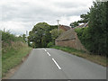
Lower House Lane by Baddesley Farm
This country is towards the northern edge of the Arden region. The land falls away unevenly to the valley of the northwest-flowing river Anker.
Image: © Robin Stott
Taken: 14 Aug 2011
0.03 miles
2
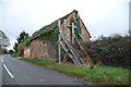
Derelict building near Baddesley Farm
I would imagine that this is a listed building, to take all this trouble to keep it standing, what happens when the wood rots away.
Image: © Mick Malpass
Taken: 11 Dec 2011
0.05 miles
3
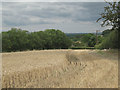
Part-harvested field behind Stone Cottage
Some chickens were having a feast. The relative height of this country only becomes apparent when a gap in the tree cover reveals the distant landscape below.
Image: © Robin Stott
Taken: 14 Aug 2011
0.07 miles
4
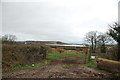
Looking over farmland to the slag heap left by Birch Coppice Mine
There is a great deal of factory units being built in this area, as it is the junction of the A5 and M42.
Image: © Mick Malpass
Taken: 11 Dec 2011
0.15 miles