IMAGES TAKEN NEAR TO
Inverary Close, KENILWORTH, CV8 2NZ
Introduction
This page details the photographs taken nearby to Inverary Close, CV8 2NZ by members of the Geograph project.
The Geograph project started in 2005 with the aim of publishing, organising and preserving representative images for every square kilometre of Great Britain, Ireland and the Isle of Man.

There are currently over 7.5m images from over14,400 individuals and you can help contribute to the project by visiting https://www.geograph.org.uk
Image Map (Loading...)


Getting Data...Please wait
Leaflet Map data © OpenStreetMap
Images are licensed for reuse under creativecommons.org/licenses/by-sa/2.0
Notes
- Clicking on the map will re-center to the selected point.
- The higher the marker number, the further away the image location is from the centre of the postcode.
Image Listing (22 Images Found)
Images are licensed for reuse under creativecommons.org/licenses/by-sa/2.0
Image
Details
Distance
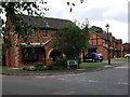
1
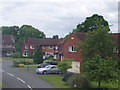
Housing Development
These houses were built in Kenilworth about 20 years ago and are now much sought-after as large, modern detached family homes.
Image: © David Williams
Taken: 28 May 2006
0.10 miles
3
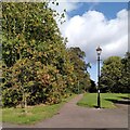
Toto, I have a feeling we're not in Kenilworth anymore
It's not Oz, though - but it could be Narnia. Best watch out for witches, either way. This is a continuation of Image], an old field path now enveloped by suburbia, which continues to expand south and east towards the A46 Kenilworth Bypass.
Image: © A J Paxton
Taken: 3 Oct 2023
0.13 miles
4
Kenilworth School, Leyes Lane
Full title: Kenilworth School and Sports College. Straight ahead is the lottery-funded Meadow dual-use sports centre.
Image: © Robin Stott
Taken: 17 Jan 2010
0.13 miles
5
Warton Close, Kenilworth
Red brick houses (probably built in the 1980's) at the junction with Mayfield Drive.
Image: © John Brightley
Taken: 30 Aug 2010
0.15 miles
6
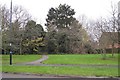
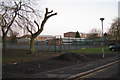
Greenspace off Dencer Drive, eastern Kenilworth
The path leads through informal open space to Warton Close, Casita Grove and beyond to Windy Arbour.
Image: © Robin Stott
Taken: 27 Nov 2009
0.18 miles
7
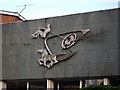
Walter Ritchie sculpture 'Growth' at Kenilworth School
For context see Image
'Growth' is made of aluminium and was installed in 1965.
It 'combines simplified figurative elements with semi-abstract biomorphic forms and musical notation against a slate architectural background..The central motif is that of a cell dividing and reproducing itself...The musical notation comes from Beethoven's Missa Solemnis. There is a male figure sitting at the joystick control of an invisible craft. He signifies man's ambitions to explore the limits. The horse symbolises the beneficial power of nature when harnessed to man's endeavour..
(details from 'Public Sculpture of Coventry, Warwickshire and Solihull, by George Noszlopy (Liverpool University Press, 2003))
Image: © John Brightley
Taken: 4 Jul 2010
0.18 miles
8
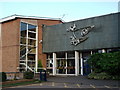
Entrance to Upper School, Kenilworth School, Leyes Lane
The sculpture above the entrance doors was crafted by Walter Ritchie - see Image]
Image: © John Brightley
Taken: 4 Jul 2010
0.18 miles
9
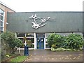
Kenilworth School
The sculpture over the Upper School entrance is 'Growth' commissioned for the school and executed by Walter Ritchie in 1965.
Image: © E Gammie
Taken: 6 Oct 2018
0.19 miles
10
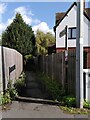
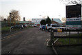
Suburban footpath, Windy Arbour
The path runs eastwards to Dencer Drive (via Narnia - see Image]), following the route it took when it was a path through fields, as the OS Six Inch map series shows.
Image: © A J Paxton
Taken: 3 Oct 2023
0.19 miles