
IMAGES TAKEN NEAR TO
Orchard Lane, KENILWORTH, CV8 2AN
Introduction
This page details the photographs taken nearby to Orchard Lane, CV8 2AN by members of the Geograph project.
The Geograph project started in 2005 with the aim of publishing, organising and preserving representative images for every square kilometre of Great Britain, Ireland and the Isle of Man.

There are currently over 7.5m images from over14,400 individuals and you can help contribute to the project by visiting https://www.geograph.org.uk
Image Map
Images are licensed for reuse under creativecommons.org/licenses/by-sa/2.0
Notes
- Clicking on the map will re-center to the selected point.
- The higher the marker number, the further away the image location is from the centre of the postcode.
Image Listing (14 Images Found)
Images are licensed for reuse under creativecommons.org/licenses/by-sa/2.0
Image
Details
Distance
1
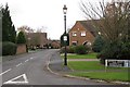
Heyville Croft off Glasshouse Lane, Kenilworth
Image: © Robin Stott
Taken: 27 Nov 2009
0.08 miles
2
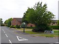
Heyville Croft Kenilworth
This housing estate was part of the huge housing development on the eastern side of Kenilworth that took place in 80's and 90's. This is the view from the junction of Glasshouse Lane and Ashow Lane.
Image: © Nigel Mykura
Taken: 18 Jul 2010
0.14 miles
3
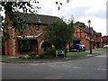
Warton Close, Kenilworth
Red brick houses (probably built in the 1980's) at the junction with Mayfield Drive.
Image: © John Brightley
Taken: 30 Aug 2010
0.15 miles
4
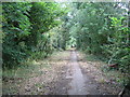
Public Bridleway to Thickthorn Wood and Ashow
Looking from the Kenilworth end towards the A46 bridge in the distance.
Image: © David Stowell
Taken: 30 Jul 2005
0.17 miles
5
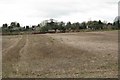
Stubble and stable manure
South of Glasshouse Lane, Kenilworth, seen from the northern leg of Rocky Lane Image
Image: © Robin Stott
Taken: 27 Nov 2009
0.18 miles
6
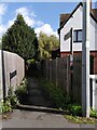
Suburban footpath, Windy Arbour
The path runs eastwards to Dencer Drive (via Narnia - see Image]), following the route it took when it was a path through fields, as the OS Six Inch map series shows.
Image: © A J Paxton
Taken: 3 Oct 2023
0.19 miles
7
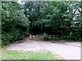
Ashow Lane or Rocky Lane, Kenilworth
Ashow Lane, or Rocky Lane, is a very old road that used to run from Glasshouse Lane in Kenilworth down to the small village of Ashow on the banks of the Avon. I can remember walking and cycling down that lane many times in the 1960's when I was a boy. The lane was cut in half when the Kenilworth by-pass was opened in 1974 and was no longer passable to motor traffic. A foot bridge was built over the new road. Since then the greenery has encroached on the tarmac narrowing it considerably, but it is still well used for walking. This is the view from the Glasshouse lane junction.
Image: © Nigel Mykura
Taken: 18 Jul 2010
0.19 miles
8
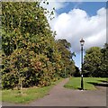
Toto, I have a feeling we're not in Kenilworth anymore
It's not Oz, though - but it could be Narnia. Best watch out for witches, either way. This is a continuation of Image], an old field path now enveloped by suburbia, which continues to expand south and east towards the A46 Kenilworth Bypass.
Image: © A J Paxton
Taken: 3 Oct 2023
0.19 miles
9
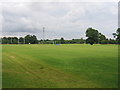
Rugby Fields
On the outskirts of Kenilworth adjacent to the Rocky Lane bridleway.
Image: © David Stowell
Taken: 30 Jul 2005
0.20 miles
10
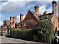
Tall chimneys on Windy Arbour
These two pairs of semi-detached houses form a striking contrast to the surrounding modern Kenilworth suburbia. I have not been able to find out anything about them. They have a Bournville, Arts & Crafts look to them, which would suggest a late 19th or early 20th century date, but they are not on the OS Six Inch map from that era. They look a bit too grand for estate cottages. Some of the chimneys lean alarmingly.
Image: © A J Paxton
Taken: 3 Oct 2023
0.20 miles