IMAGES TAKEN NEAR TO
Bridge Street, KENILWORTH, CV8 1RN
Introduction
This page details the photographs taken nearby to Bridge Street, CV8 1RN by members of the Geograph project.
The Geograph project started in 2005 with the aim of publishing, organising and preserving representative images for every square kilometre of Great Britain, Ireland and the Isle of Man.

There are currently over 7.5m images from over14,400 individuals and you can help contribute to the project by visiting https://www.geograph.org.uk
Image Map
Images are licensed for reuse under creativecommons.org/licenses/by-sa/2.0
Notes
- Clicking on the map will re-center to the selected point.
- The higher the marker number, the further away the image location is from the centre of the postcode.
Image Listing (302 Images Found)
Images are licensed for reuse under creativecommons.org/licenses/by-sa/2.0
Image
Details
Distance
1
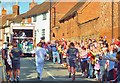
Olympic Torch in New Street Kenilworth
The Olympic Torch Relay progresses through New Street Kenilworth.
The convoy includes the "media truck".
Image: © John Evans
Taken: 1 Jul 2012
0.02 miles
2
New Street Kenilworth
The A429 New Street viewed from High Street.
Image: © Jaggery
Taken: 8 Aug 2018
0.02 miles
3
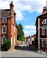
Three-storey building on a Kenilworth corner
On the corner of New Street and Bridge Street.
Image: © Jaggery
Taken: 8 Aug 2018
0.03 miles
4
Kenilworth: along New Street
Looking in the Coventry direction on a June morning. Many of these buildings are Grade II listed.
Image: © John Sutton
Taken: 4 Jun 2019
0.03 miles
5
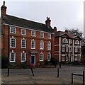
Corner of New Street & Fieldgate Lane, Kenilworth
On the left stand 1 & 2 Fieldgate Lane, dating from the early 18th century, according to the listing at Historic England https://historicengland.org.uk/listing/the-list/list-entry/1365690?section=official-list-entry .
On the right on Bridge Street is Abbotsford House, also a listed building and dating from the late 18th century, according to the listing. It was once known as Bridge House and during the First World War it housed Belgian refugees. When they moved out, Abbotsford School moved in and it acquired its current name. By 2018 the school had moved again and the house was being converted into flats; see the site of the Kenilworth History & Archaeology Society https://www.khas.co.uk/bridge-street-from-high-street-then-now/ .
Between the two houses, New Street empties traffic from Coventry, including double decker buses, into the old town.
Image: © A J Paxton
Taken: 10 Oct 2023
0.03 miles
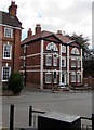
6
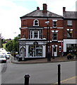
Classics Hair & Beauty in Kenilworth
Salon at 1 High Street on the corner of Bridge Street.
Image: © Jaggery
Taken: 8 Aug 2018
0.03 miles
7
Waiting at the traffic lights
This is the junction of the A429 and the A452. The photographer is in New Street. To the right is Fieldgate Lane, straight on is the High Street, and left is Bridge Street. Note the stop line for the lights is well back up New Street. This is to allow traffic to turn the corners in a very tight and blind junction.
Image: © David P Howard
Taken: 16 Aug 2010
0.03 miles
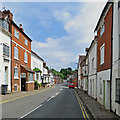
8
Kenilworth: Bridge Street traffic lights
Turn left for Kenilworth Castle, right for Coventry or go straight on to Balsall Common.
Image: © John Sutton
Taken: 4 Jun 2019
0.03 miles
9
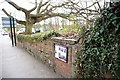
Former air raid shelter
The plaque on this wall marks the bricked up entrance to a second world war air raid shelter built in Kenilworth. The structure still survives underground and continues as a mound over the other side of the wall. It stretches as far as the tree seen in the picture. The plaque gives details of this and some other war remains in the town.
Image: © Colin Craig
Taken: 20 Mar 2011
0.04 miles
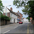
10
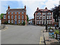
Kenilworth: fine houses at the crossroads
Looking from High Street towards New Street, the Coventry road. The grand 18th-century houses are Grade II (left) and Grade II* listed.
Image: © John Sutton
Taken: 4 Jun 2019
0.04 miles