IMAGES TAKEN NEAR TO
Warwick Road, KENILWORTH, CV8 1FD
Introduction
This page details the photographs taken nearby to Warwick Road, CV8 1FD by members of the Geograph project.
The Geograph project started in 2005 with the aim of publishing, organising and preserving representative images for every square kilometre of Great Britain, Ireland and the Isle of Man.

There are currently over 7.5m images from over14,400 individuals and you can help contribute to the project by visiting https://www.geograph.org.uk
Image Map (Loading...)


Getting Data...Please wait
Leaflet Map data © OpenStreetMap
Images are licensed for reuse under creativecommons.org/licenses/by-sa/2.0
Notes
- Clicking on the map will re-center to the selected point.
- The higher the marker number, the further away the image location is from the centre of the postcode.
Image Listing (70 Images Found)
Images are licensed for reuse under creativecommons.org/licenses/by-sa/2.0
Image
Details
Distance
1
A452 Leamington Road Warwick Road to the Left
Image: © Roy Hughes
Taken: 9 Oct 2013
0.03 miles
2

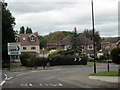
Entering a small gyratory system in Kenilworth
This is where the original roads from Leamington and Warwick met at the bottom of the high street. St John's Church is in the background.
Image: © Bill Boaden
Taken: 16 Jul 2022
0.04 miles
3

Warwick Road, Kenilworth
The old main road to Warwick before the new A46 changed the local configuration. It is bounded by fairly substantial residential properties.
Image: © Bill Boaden
Taken: 16 Jul 2022
0.04 miles
4
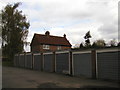
Jet Garage, Kenilworth
There are two garages very close to each other which is unusual for a town of this size.
Image: © Anthony Vosper
Taken: 13 Oct 2012
0.06 miles
5
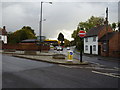
Kenilworth
The one way system at the junction of the old Leek Wootton/Warwick Road and the Leamington Road.
Image: © David Stowell
Taken: 27 Aug 2005
0.06 miles
6
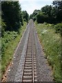
Railway line leaving Kenilworth heading for Leamington Spa
View south from the southern of the two bridges forming a road island on the A452 as it enters Kenilworth.
Image: © David P Howard
Taken: 22 Jun 2010
0.07 miles
7
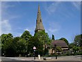
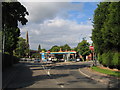
St John's Church, Kenilworth
View from the road island on the A452 as it enters Kenilworth. The church website is here http://www.kenjohn.plus.com/
Image: © David P Howard
Taken: 22 Jun 2010
0.08 miles
8
The rear of 1 White's Row, Kenilworth
Taken from the garage court of the adjacent flats.
1 White's Row was demolished c.2005 and two blocks of apartments were built on the site.
Image: © John Brightley
Taken: 20 Apr 2004
0.08 miles
9
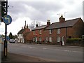
194-200 Warwick Road, Kenilworth
The photo is taken from the entrance to St John's Church car park, with the Jet petrol station just visible on the left.
The white cottage on the left is 200 Warwick Road and the small single storey building to the right of it used to be a smithy. The house to the right of that (198 Warwick Road), was a pub, the Malt Shovel, from before 1835 to its closure in 1923. It was sometimes known as 'The Mouse Trap'.
Warwick Road was known as Castle End until about 1890.
(Some of the information above is obtained from 'The Inns and Roads of Kenilworth' by Rob Steward (2000))
Image: © John Brightley
Taken: 20 Apr 2004
0.08 miles
10
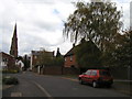
White's Row, Kenilworth
Looking eastwards towards St.John's church. The road straight ahead is the original line of the street, leading to Warwick Road. The tall Georgian houses in the background on the right of the street are 190-192 Warwick Road - a view of the front of these houses can be found at Image The section of White's Row that curves off to the left was built in the 1970's and can be seen at Image 1 White's Row, on the right, was demolished c.2005.
Image: © John Brightley
Taken: 20 Apr 2004
0.09 miles