IMAGES TAKEN NEAR TO
Pears Close, KENILWORTH, CV8 1BS
Introduction
This page details the photographs taken nearby to Pears Close, CV8 1BS by members of the Geograph project.
The Geograph project started in 2005 with the aim of publishing, organising and preserving representative images for every square kilometre of Great Britain, Ireland and the Isle of Man.

There are currently over 7.5m images from over14,400 individuals and you can help contribute to the project by visiting https://www.geograph.org.uk
Image Map
Images are licensed for reuse under creativecommons.org/licenses/by-sa/2.0
Notes
- Clicking on the map will re-center to the selected point.
- The higher the marker number, the further away the image location is from the centre of the postcode.
Image Listing (304 Images Found)
Images are licensed for reuse under creativecommons.org/licenses/by-sa/2.0
Image
Details
Distance
1

Frost on trees by Finham Brook
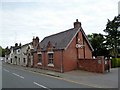
The shared footpath and cycleway leads from Manor Road to Abbey Fields and this section is behind houses in School Lane.
Image: © John Brightley
Taken: 7 Dec 2010
0.06 miles
2
Kenilworth-The Cross
Public House on New Street.
Image: © Ian Rob
Taken: 19 May 2016
0.07 miles
3
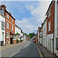
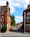
Kenilworth: along New Street
Looking in the Coventry direction on a June morning. Many of these buildings are Grade II listed.
Image: © John Sutton
Taken: 4 Jun 2019
0.07 miles
5
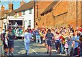
Olympic Torch in New Street Kenilworth
The Olympic Torch Relay progresses through New Street Kenilworth.
The convoy includes the "media truck".
Image: © John Evans
Taken: 1 Jul 2012
0.08 miles
6
New Street Kenilworth
The A429 New Street viewed from High Street.
Image: © Jaggery
Taken: 8 Aug 2018
0.08 miles
7
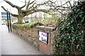
Former air raid shelter
The plaque on this wall marks the bricked up entrance to a second world war air raid shelter built in Kenilworth. The structure still survives underground and continues as a mound over the other side of the wall. It stretches as far as the tree seen in the picture. The plaque gives details of this and some other war remains in the town.
Image: © Colin Craig
Taken: 20 Mar 2011
0.08 miles
8
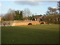
Kenilworth, bridge
C18 sandstone bridge on Bridge Street, over Finham Brook. The darker horizontal band over the arch shows water level in 1874. As seen from Abbey Fields; listed by English Heritage, http://www.imagesofengland.org.uk/Details/Default.aspx?id=307734&mode=adv
Image: © Mike Faherty
Taken: 6 Mar 2010
0.09 miles
9
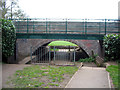
Low headroom
The bridge carrying Bridge Street/Rosemary Hill across the Finham Brook has a pedestrian underpass through one arch which gives access to Abbey Fields.
The other side: Image]
Image: © E Gammie
Taken: 16 Apr 2012
0.09 miles
10
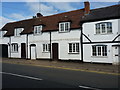
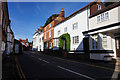
23 (part) & 25 New Street, Kenilworth
Most of no 23 to the left, and the whole of no 25 New Street, which date from the 17th century, or possibly earlier. They were collectively Grade II listed https://britishlistedbuildings.co.uk/101364893-23-and-25-new-street-kenilworth#.XVA1kuhKjcs & https://historicengland.org.uk/listing/the-list/list-entry/1364893 in 1971.
Image: © Richard Law
Taken: 27 Jun 2019
0.09 miles