IMAGES TAKEN NEAR TO
Easter Way, COVENTRY, CV7 9HP
Introduction
This page details the photographs taken nearby to Easter Way, CV7 9HP by members of the Geograph project.
The Geograph project started in 2005 with the aim of publishing, organising and preserving representative images for every square kilometre of Great Britain, Ireland and the Isle of Man.

There are currently over 7.5m images from over14,400 individuals and you can help contribute to the project by visiting https://www.geograph.org.uk
Image Map
Images are licensed for reuse under creativecommons.org/licenses/by-sa/2.0
Notes
- Clicking on the map will re-center to the selected point.
- The higher the marker number, the further away the image location is from the centre of the postcode.
Image Listing (48 Images Found)
Images are licensed for reuse under creativecommons.org/licenses/by-sa/2.0
Image
Details
Distance
1
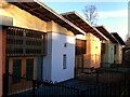
Detail of former school building at the Pears Centre, Ash Green
For more on the RNIB Pears Centre for Specialist Learning see here Image
Image: © A J Paxton
Taken: 22 Mar 2020
0.04 miles
2
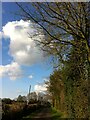
Walking along Blackberry Lane in spring, looking towards Ash Green
Blackberry Lane is marked on the Six Inch OS map, 1888-1913 series, as Rookery Lane, although the adjoining farm is called Blackberry Hall. https://maps.nls.uk/geo/explore/side-by-side/#zoom=16&lat=52.45443&lon=-1.51588&layers=6&right=OSAPI
Image: © A J Paxton
Taken: 6 Apr 2020
0.05 miles
3
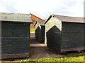
A gathering of sheds
Four sheds, three of them visible here, stood in a rectangle in the grounds of the RNIB Pears Centre for Specialist Learning at Ash Green. In the background can be seen the hydrotherapy pool building with its wooden siding and single pitch roof. For an outline of the brief history of the Pears Centre see its Wikipedia article here https://en.wikipedia.org/wiki/RNIB_Pears_Centre_for_Specialist_Learning.
Image: © A J Paxton
Taken: 25 Oct 2020
0.06 miles
4

Playing field, Blackberry Lane CV7
Across the road from Exhall Grange School.
Image: © Robin Stott
Taken: 11 Oct 2010
0.10 miles
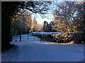
5
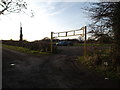
Sports field and car park
At the end of Blackberry Lane.
Image: © Niki Walton
Taken: 29 Dec 2018
0.11 miles
6
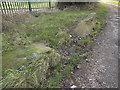
Remnants on Blackberry Lane
Several rectangular blocks and one irregular block on the side of the trackway on Blackberry Lane. There's no other indication of what these were previously part of.
Image: © Niki Walton
Taken: 29 Dec 2018
0.11 miles
7
Blackberry Lane, Ash Green
Blackberry Lane provides access to a farmhouse but does not appear to be a public right of way. It is nonetheless a much-used footpath, a peaceful back road running parallel to Wheelwright Lane in Ash Green.
Image: © A J Paxton
Taken: 25 Jan 2021
0.11 miles
8

Autumn mist, Blackberry Lane
Mist hangs over the Ash Green playing field by Blackberry Lane on a November morning in 2020.
Image: © A J Paxton
Taken: 6 Nov 2020
0.11 miles
9
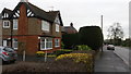
Housing on Wheelwright Lane
Wheelwright Lane is an arterial route from Coventry city centre to is northern suburbs. Neil's Green is a prosperous area with detached housing of which this picture is an example.
Image: © Peter Mackenzie
Taken: 3 Jan 2017
0.11 miles
10
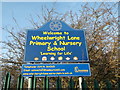
Wheelwright Lane school sign
The school has been on this site since before the Second World War.
Image: © Niki Walton
Taken: 29 Dec 2018
0.12 miles