
IMAGES TAKEN NEAR TO
The Chase, CV7 8SG
Introduction
This page details the photographs taken nearby to The Chase, CV7 8SG by members of the Geograph project.
The Geograph project started in 2005 with the aim of publishing, organising and preserving representative images for every square kilometre of Great Britain, Ireland and the Isle of Man.

There are currently over 7.5m images from over14,400 individuals and you can help contribute to the project by visiting https://www.geograph.org.uk
Image Map
Images are licensed for reuse under creativecommons.org/licenses/by-sa/2.0
Notes
- Clicking on the map will re-center to the selected point.
- The higher the marker number, the further away the image location is from the centre of the postcode.
Image Listing (26 Images Found)
Images are licensed for reuse under creativecommons.org/licenses/by-sa/2.0
Image
Details
Distance
1
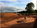
Housing development on site of Coventry Colliery Social Club
The houses are being built on a strip of land alongside Bennetts Road in Keresley, on the site of the old club, its bowling greens and 5-a-side football pitch. Coventry Colliery Bowls Club has moved further up Bennetts Road North to a site on the rugby club grounds. https://www.coventrytelegraph.net/news/coventry-news/site-former-sports-club-coventry-19254793 The Coventrians football club continues to occupy part of the land between the development and Bunsons Wood. Their clubhouse can be seen in the centre of the picture behind the mound of earth, while players can be seen on the right behind the oak tree.
Image: © A J Paxton
Taken: 11 Jun 2021
0.03 miles
3
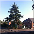
Cedar, Bennetts Road North, Keresley
This fine tree stands in the grounds of the former Coventry Colliery Sports & Social Club, which are now being redeveloped with housing. The tree, and two more of its type not visible in this photo, are being incorporated into the new development. I suspect this of being a deodar cedar, on account of the drooping tips of the branches, but would welcome help with identification. It had a fine crop of cones.
Image: © A J Paxton
Taken: 8 Aug 2022
0.05 miles
4
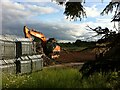
Fencing and digger on housing construction site, Bennetts Road, Keresley
The site of the Coventry Colliery Social Club is being redeveloped with houses.
Image: © A J Paxton
Taken: 11 Jun 2021
0.05 miles
5
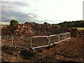
Heap of rubble on site of Coventry Colliery Social Club
The rubble of the club building, demolished several years ago, is being removed to make way for housing. Bunsons Wood can be seen in the distance.
Image: © A J Paxton
Taken: 11 Jun 2021
0.05 miles
6

Keresley Clinic
Warwickshire NHS Trust's local clinic in Keresley.
Image: © Peter Mackenzie
Taken: 29 Dec 2018
0.05 miles
7
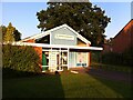
Keresley Library, Keresley End
The library serves the village at Keresley End, near to Prologis Park, the business park that occupies the site of the former Coventry Colliery. The settlement lies beyond the Coventry city boundary in Nuneaton & Bedworth borough, which forms part of the county of Warwickshire.
The library was closed by Warwickshire County Council during the period of 'austerity' and budget cuts following the financial crisis of 2007-2009, but has been kept running as a community library staffed by volunteers and stocking Warwichshire county library books and materials. Its web page can be found at the site of Keresley parish council https://keresley-pc.gov.uk/library.html .
Image: © A J Paxton
Taken: 7 Sep 2021
0.07 miles
8
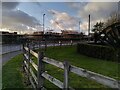
Housebuilding on Bennetts Road North, Keresley
The houses are being built on the site of the Coventry Colliery Sports & Social Club. At the right hand side can be seen part of the colliery monument.
Image: © A J Paxton
Taken: 24 Feb 2022
0.07 miles
9
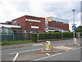
Coventry & Keresley Colliery Sports and Social Club
Image: © David Stowell
Taken: 27 Aug 2006
0.07 miles
10
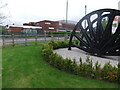
Coventry Colliery Social Club, Bennetts Road, Keresley
Coventry Colliery closed in 1991, but the social club continued until 2012. https://www.coventrytelegraph.net/news/coventry-news/coventry-colliery-club-closes-losses-3024448 It has since been demolished. To the right of the picture can be seen a monument to the workers at the colliery and associated smokeless fuel plant.
Image: © A J Paxton
Taken: 4 May 2012
0.08 miles