IMAGES TAKEN NEAR TO
Heywood Close, COVENTRY, CV6 7NW
Introduction
This page details the photographs taken nearby to Heywood Close, CV6 7NW by members of the Geograph project.
The Geograph project started in 2005 with the aim of publishing, organising and preserving representative images for every square kilometre of Great Britain, Ireland and the Isle of Man.

There are currently over 7.5m images from over14,400 individuals and you can help contribute to the project by visiting https://www.geograph.org.uk
Image Map
Images are licensed for reuse under creativecommons.org/licenses/by-sa/2.0
Notes
- Clicking on the map will re-center to the selected point.
- The higher the marker number, the further away the image location is from the centre of the postcode.
Image Listing (4 Images Found)
Images are licensed for reuse under creativecommons.org/licenses/by-sa/2.0
Image
Details
Distance
1

Sewall Highway, Courthouse Green
An unusual feature in this area- a crescent built I think in the 1950's as council houses, with a very large green space between them and the main carriageway of Sewall Highway. The road in front of these houses does not have a different name -the houses are all given a Sewall Highway address.
Image: © John Brightley
Taken: 25 May 2010
0.10 miles
2
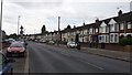
Terraced housing
Terraced houses in the Bell Green district of Coventry.
Image: © Peter Mackenzie
Taken: 27 Jul 2017
0.15 miles
3
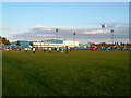
Courthouse Green
Once the Morris Engine Works. Now home to the AT7 Sports Centre, a car hypermarket and Sainsbury's supermarket.
Image: © Kevin Croucher
Taken: 13 Jun 2005
0.15 miles
4
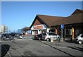
J Sainsbury Courthouse Green
Superstore in Austin Drive.
Image: © Ian Rob
Taken: 9 Jan 2011
0.17 miles