IMAGES TAKEN NEAR TO
Friswell Drive, COVENTRY, CV6 7NG
Introduction
This page details the photographs taken nearby to Friswell Drive, CV6 7NG by members of the Geograph project.
The Geograph project started in 2005 with the aim of publishing, organising and preserving representative images for every square kilometre of Great Britain, Ireland and the Isle of Man.

There are currently over 7.5m images from over14,400 individuals and you can help contribute to the project by visiting https://www.geograph.org.uk
Image Map
Images are licensed for reuse under creativecommons.org/licenses/by-sa/2.0
Notes
- Clicking on the map will re-center to the selected point.
- The higher the marker number, the further away the image location is from the centre of the postcode.
Image Listing (82 Images Found)
Images are licensed for reuse under creativecommons.org/licenses/by-sa/2.0
Image
Details
Distance
1
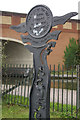
Spring Road entrance marker, Coventry Canal
This sign marks the entrance to the towpath close to bridge 6A which carries the A444, Phoenix Way, where the Coventry Loop Line railway used to run. This industrial area suffered particularly badly during the Coventry blitz; in some cases, the canal water was used to extinguish the fires.
Image: © Stephen McKay
Taken: 19 Oct 2008
0.07 miles
2
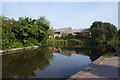
![A stroll along the Coventry Canal to Hawkesbury Junction [28]](https://s3.geograph.org.uk/geophotos/07/12/19/7121947_2098493a_120x120.jpg)
A stroll along the Coventry Canal to Hawkesbury Junction [28]
Seen alongside the canal, these buildings appear to be neglected and abandoned by all except the graffiti artists.
The narrow canal was built to connect the city of Coventry with the Trent & Mersey Canal, some 38 miles distant, to exploit the Warwickshire coalfields. Construction of the canal took 20 years before it was complete in 1769. The canal between the basin in Coventry and Hawkesbury junction was made a conservation area in 2012.
Image: © Michael Dibb
Taken: 23 Sep 2021
0.07 miles
3
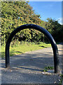
Traffic barrier
Located on a footpath approaching the Coventry Canal.
Image: © Alan Hughes
Taken: 23 Sep 2021
0.08 miles
4
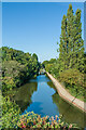
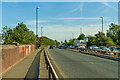
Coventry Canal
The Coventry Canal viewed from Spring Road Canal Bridge (designated bridge 6A).
Image: © Ian Capper
Taken: 23 Sep 2021
0.08 miles
5
Spring Road entrance marker, Coventry Canal
See Image The marker is still here, telling the same story, 13 years on.
Image: © Stephen McKay
Taken: 11 Sep 2021
0.08 miles
6
![A stroll along the Coventry Canal to Hawkesbury Junction [25]](https://s0.geograph.org.uk/geophotos/07/12/19/7121944_490311a7_120x120.jpg)
A stroll along the Coventry Canal to Hawkesbury Junction [25]
Steps rising to Jimmy Hill Way, A444, being carried over the canal on bridge number 6a.
The narrow canal was built to connect the city of Coventry with the Trent & Mersey Canal, some 38 miles distant, to exploit the Warwickshire coalfields. Construction of the canal took 20 years before it was complete in 1769. The canal between the basin in Coventry and Hawkesbury junction was made a conservation area in 2012.
Image: © Michael Dibb
Taken: 23 Sep 2021
0.08 miles
7
Jimmy Hill Way
The A444 Jimmy Hill Way crossing Spring Road Canal Bridge (designated bridge 6A). The bridge was constructed in 1996 when the A444 was built along the line of the former Coventry Loop Line railway which was built in 1914 but closed as a through route in 1963 and completely in 1981. Originally named Phoenix Way it was renamed Jimmy Hill Way in 2016, in honour of the former Coventry City FC manager who had died in December 2015. Spring Road itself is a nearby road (now a cul-de-sac) running parallel to the canal - it is unclear why the name has been applied to this build.
Image: © Ian Capper
Taken: 23 Sep 2021
0.08 miles
9
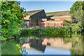
Former textile factory
Former textile factory alongside the Coventry Canal, later housing a conservatory manufacturer. At this point the canal widens to form Foleshill winding hole, put in place for turning boats.
Image: © Ian Capper
Taken: 23 Sep 2021
0.09 miles
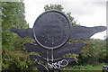
10
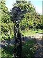
Canal Milepost
Similar to the millennium mileposts, but the winding space up the middle is actually a map of the first few miles of the Coventry Canal.
Image: © Anne Burgess
Taken: 23 Sep 2021
0.09 miles