
IMAGES TAKEN NEAR TO
Sewall Highway, COVENTRY, CV6 7JB
Introduction
This page details the photographs taken nearby to Sewall Highway, CV6 7JB by members of the Geograph project.
The Geograph project started in 2005 with the aim of publishing, organising and preserving representative images for every square kilometre of Great Britain, Ireland and the Isle of Man.

There are currently over 7.5m images from over14,400 individuals and you can help contribute to the project by visiting https://www.geograph.org.uk
Image Map
Images are licensed for reuse under creativecommons.org/licenses/by-sa/2.0
Notes
- Clicking on the map will re-center to the selected point.
- The higher the marker number, the further away the image location is from the centre of the postcode.
Image Listing (5 Images Found)
Images are licensed for reuse under creativecommons.org/licenses/by-sa/2.0
Image
Details
Distance
1

Sewall Highway, Courthouse Green
An unusual feature in this area- a crescent built I think in the 1950's as council houses, with a very large green space between them and the main carriageway of Sewall Highway. The road in front of these houses does not have a different name -the houses are all given a Sewall Highway address.
Image: © John Brightley
Taken: 25 May 2010
0.08 miles
2
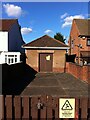
Electricity substation, Blackberry Lane
Nestled between two suburban homes, this substation is topped with a pitched and hipped roof and has its own front yard with wall, fence and gate; a little house for the electric gods.
Image: © A J Paxton
Taken: 8 Oct 2022
0.15 miles
3

Sub station on Blackberry Lane, close to the Sewall Highway junction
Note the lintel which is made by sandwiching layers of mortar between a series of vertical roof tiles.
Image: © starkderrick
Taken: 11 Oct 2011
0.16 miles
4

The River Sowe at Henley Mill, Coventry
The Sowe is here flowing eastwards, away from the camera, completing a large loop around Henley Mill Lane. The mill has long since vanished, though traces of a mill race are marked on the OS map and the Victorian mill house has survived. See Image
Image: © A J Paxton
Taken: 11 Nov 2023
0.17 miles
5

Henley Mill, Henley Green, Coventry
Henley Mill Lane is a curious survival in urban Coventry, a tree-lined country lane around which the River Sowe meanders in a large loop. Henley Mill is mentioned in the 14th century, but fell into disuse in the 19th and was replaced by the Foleshill sewage works, which was in turn replaced by allotments. The Victorian mill house has survived and can be seen in this picture. See the Victoria County History of Warwickshire, Vol. 8 https://www.british-history.ac.uk/vch/warks/vol8/pp190-198#:~:text=HENLEY%20MILL%20was%20on%20the,land%20from%20Coventry%20Priory%20there.
Image: © A J Paxton
Taken: 9 Apr 2023
0.22 miles