IMAGES TAKEN NEAR TO
Burbages Lane, COVENTRY, CV6 6AW
Introduction
This page details the photographs taken nearby to Burbages Lane, CV6 6AW by members of the Geograph project.
The Geograph project started in 2005 with the aim of publishing, organising and preserving representative images for every square kilometre of Great Britain, Ireland and the Isle of Man.

There are currently over 7.5m images from over14,400 individuals and you can help contribute to the project by visiting https://www.geograph.org.uk
Image Map
Images are licensed for reuse under creativecommons.org/licenses/by-sa/2.0
Notes
- Clicking on the map will re-center to the selected point.
- The higher the marker number, the further away the image location is from the centre of the postcode.
Image Listing (43 Images Found)
Images are licensed for reuse under creativecommons.org/licenses/by-sa/2.0
Image
Details
Distance
1
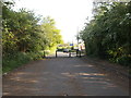
Bollards, Burbages Lane
Burbages Lane was closed off at the Coventry end in 2004 due to the construction of nearby Winding House Lane, a dual carriageway designed to cope with the heavy traffic expected in the area with the construction of the nearby Ricoh Arena and Shopping Park.
Image: © Niki Walton
Taken: 4 May 2017
0.02 miles
2
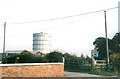
Beaurhys Border Collies and Foleshill Gas Tower
Foleshill Gas Tower looks in the background over Burbages Lane for one last day. Meanwhile, a dog breeding establishment advertises itself alongside horse manure for sale.
Image: © Niki Walton
Taken: 21 Sep 2002
0.02 miles
3
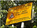
Permanent road closure
Before the construction of the nearby dual-carriageway Winding House Lane, Burbages Lane connected Wheelwright Lane with Holbrooks and Rowleys Green. It was closed permanently at the A444 end once Winding House Lane was established.
Image: © Niki Walton
Taken: 4 May 2017
0.03 miles
4

Field maple, Burbages Lane
This is a detail of a field maple, Acer campestre, in its autumn glory and with one of its winged fruits. For more on the field maple, see the Woodland Trust site here https://www.woodlandtrust.org.uk/trees-woods-and-wildlife/british-trees/a-z-of-british-trees/field-maple/ .
Image: © A J Paxton
Taken: 7 Nov 2020
0.04 miles
5
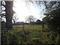
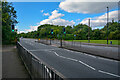
Field off Burbages Lane
Burbages Lane, just north of the Coventry/Warwickshire border, still has something of a rural feel despite being close to a major sports stadium and shopping hub - you just have to know where to look.
Image: © Niki Walton
Taken: 4 May 2017
0.08 miles
6
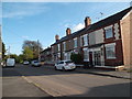
Terraced houses, Burbages Lane
Burbages Lane contains a variety of house styles, including this short run of terraced houses near the now-closed-off Coventry end.
Image: © Niki Walton
Taken: 4 May 2017
0.09 miles
7
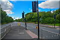
Coventry : Winding House Lane
Looking along Winding House Lane.
Image: © Lewis Clarke
Taken: 25 Sep 2021
0.10 miles
8
Bungalows, Burbages Lane
Amongst the variety of house styles in Burbages Lane are this short row of bungalows.
Image: © Niki Walton
Taken: 4 May 2017
0.11 miles
9
Coventry : Winding House Lane
Looking along Winding House Lane.
Image: © Lewis Clarke
Taken: 25 Sep 2021
0.11 miles
10
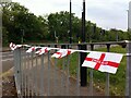
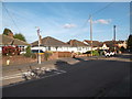
An English army had just won the war
Bunting has been hung on railings at the junction of Burbages Lane and Winding House Lane to celebrate VE (Victory in Europe) Day, the 75th anniversary of which fell on the 8th May 2020. The May Day bank holiday was moved that year to Monday 11th to permit a long weekend of celebration, but coronavirus pandemic lockdown restrictions, while they heightened the sense of national unity for many people, prevented public gatherings, with the result that celebrations found their outlet through displays; see this BBC report https://www.bbc.co.uk/news/uk-england-52572884 .
The title alludes of course to the Beatles song 'A Day in the Life' - see Wikipedia here https://en.wikipedia.org/wiki/A_Day_in_the_Life - and is not intended to suggest that Britain, still less England, was solely responsible for victory over Nazi Germany in 1945.
Image: © A J Paxton
Taken: 9 May 2020
0.12 miles