IMAGES TAKEN NEAR TO
Lockhurst Lane, COVENTRY, CV6 5NQ
Introduction
This page details the photographs taken nearby to Lockhurst Lane, CV6 5NQ by members of the Geograph project.
The Geograph project started in 2005 with the aim of publishing, organising and preserving representative images for every square kilometre of Great Britain, Ireland and the Isle of Man.

There are currently over 7.5m images from over14,400 individuals and you can help contribute to the project by visiting https://www.geograph.org.uk
Image Map (Loading...)


Getting Data...Please wait
Leaflet Map data © OpenStreetMap
Images are licensed for reuse under creativecommons.org/licenses/by-sa/2.0
Notes
- Clicking on the map will re-center to the selected point.
- The higher the marker number, the further away the image location is from the centre of the postcode.
Image Listing (31 Images Found)
Images are licensed for reuse under creativecommons.org/licenses/by-sa/2.0
Image
Details
Distance
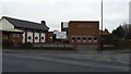
1
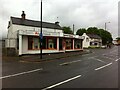
Vernacular houses, Lockhurst Lane
These two structures are the only obvious survivors of Lockhurst Lane buildings earlier than the late 19th century, and have been much extended with commercial frontages. Lockhurst Lane formed part of the parish of Foleshill and was a centre of the ribbon-weaving industry; one of the earliest co-operative societies was founded here in 1832. https://heartofengland.coop/society/roots/
Image: © A J Paxton
Taken: 21 May 2021
0.03 miles
2
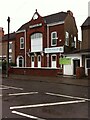
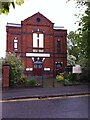
Mosque in premises of former Liberal Club
The Faizan-e-Islam mosque occupies the premises of the former Foleshill Liberal Club, which opened in 1891. https://forebears.io/england/warwickshire/foleshill#sid17390 At this time the Liberals were stronger than the Conservatives in Coventry, but they declined in the 1920s with the rise of the Labour Party. https://liberalhistory.org.uk/resources/coventry-history-centre/ The club closed in 2010. https://www.coventrytelegraph.net/news/coventry-news/foleshill-liberal-club-goes-liquidation-3056714
Image: © A J Paxton
Taken: 21 May 2021
0.05 miles
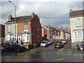
3
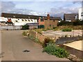
Buildings behind Park Street & Lockhurst Lane, Foleshill
This is an odd corner of Foleshill viewed through a fence from Livingstone Road. In the centre of the photo beyond the rather overgrown plot is what looks like a vernacular cottage with a crude modern extension and, behind it, some industrial buildings including a long factory building of brick.
Image: © A J Paxton
Taken: 11 Sep 2021
0.10 miles
4
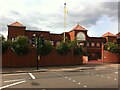
Ajit Darbar Sikh Temple, Lockhurst Lane, Foleshill
This gurdwara is dated 1962 on the front but the current building is clearly much more recent than that.
Image: © A J Paxton
Taken: 11 Sep 2021
0.10 miles
5
Church on Station Street West, Foleshill, Coventry
The Bethel New Life Apostolic Church occupies a former Methodist church erected in 1880, which replaced one built by the Free Methodists in 1837 on Carpenter's Lane, the earlier name of Station Street West. https://www.british-history.ac.uk/vch/warks/vol8/pp382-396
Image: © A J Paxton
Taken: 21 May 2021
0.11 miles
6
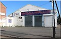
Tattoo parlour on Livingstone Road, Coventry
Image: © David Howard
Taken: 21 May 2023
0.12 miles
7
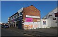
DSK electrical and lighting centre on Livingstone Road, Coventry
Image: © David Howard
Taken: 21 May 2023
0.12 miles
8
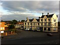
Former Railway Hotel, Boston Place, Foleshill
The former Railway Hotel in Foleshill, Coventry, is seen here from the nearby road bridge that links Lockhurst Lane and Holbrook Lane and carries them over the Coventry-Nuneaton railway.
Built to serve Foleshill station, it must have lost its purpose with the station's closure in 1965, but it found a new lease of life in the 1970s as a venue for the Indian and Caribbean communities. Annette Hay recalls in the Coventry Telegraph how, "In the 1970s one half [The Railway Pub] was owned by an Indian man, called Mr Nijjar but known as Deete, and the other half was used by the West Indians, and in the middle floor was a massive dance floor. In the West Indian side they'd be playing snooker and cards. I learnt to play snooker there, sometimes people would bring in their families, for many years many of the West Indian community would use that facility." This reflects, says Hay, a time when racism was much more explicit in Coventry and the club offered a safe space. The West Indian, now Caribbean, club moved in 1983 to premises in Spon Street (Hay is quoted here https://www.coventrytelegraph.net/news/coventry-news/extraordinary-history-coventrys-west-indian-19050407 ).
When photographed in 2021 the building was disused.
Image: © A J Paxton
Taken: 2 Sep 2021
0.14 miles
9
Evangelical Church building
Durbar Avenue Evangelical Church (affiliated to the Fellowship of Independent Evangelical Churches) is situated in the southern area of Holbrooks, Coventry.
Image: © Peter Mackenzie
Taken: 3 Jan 2017
0.17 miles
10
Coventry-Welford Place
Cul-de-sac off Lockhurst Lane.
Image: © Ian Rob
Taken: 29 Jun 2008
0.18 miles