IMAGES TAKEN NEAR TO
Curzon Avenue, COVENTRY, CV6 5LF
Introduction
This page details the photographs taken nearby to Curzon Avenue, CV6 5LF by members of the Geograph project.
The Geograph project started in 2005 with the aim of publishing, organising and preserving representative images for every square kilometre of Great Britain, Ireland and the Isle of Man.

There are currently over 7.5m images from over14,400 individuals and you can help contribute to the project by visiting https://www.geograph.org.uk
Image Map
Images are licensed for reuse under creativecommons.org/licenses/by-sa/2.0
Notes
- Clicking on the map will re-center to the selected point.
- The higher the marker number, the further away the image location is from the centre of the postcode.
Image Listing (30 Images Found)
Images are licensed for reuse under creativecommons.org/licenses/by-sa/2.0
Image
Details
Distance
2
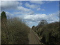
Railway towards Nuneaton
Looking north east.
Image: © JThomas
Taken: 4 Mar 2017
0.14 miles
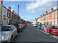
3
Beresford Avenue, Foleshill
Beresford Avenue is one of a group of early 20th century streets in suburban Coventry with names redolent of the British empire and naval power at their peak in the late 19th and early 20th centuries: Fisher, Churchill and Durbar are others. Beresford presumably refers to Admiral Charles William de la Poer Beresford, hero of campaigns in Egypt and Sudan and later an MP and Commander in Chief of the Channel Fleet and later the Mediterrannean Fleet; a summary of his life can be found at the Beresford family site http://www.beresfordfamilysociety.org/background.html . This is now one of the most multicultural districts of Coventry, with families of mainly south Asian heritage: "We are here because you were there".
Image: © A J Paxton
Taken: 14 Jul 2022
0.15 miles
4
Churchill Avenue, Coventry
View from Foleshill Road (B4113).
Image: © JThomas
Taken: 4 Mar 2017
0.17 miles
5
Valmiki Temple, Fisher Road, Foleshill
This place of worship is called Jagat Guru Valmik Ji Maharaj Temple and is dedicated to the sage and poet Valmiki, author of the Ramayana, the epic which tells of Prince Rama liberating Princess Sita from the demon-king Ravana. It occupies a former parcel sorting office which was bought by the Valmiki community in 1978; one of their members worked for Royal Mail. A community centre, which is used as a langar hall for serving food, was added ten years later.
The Valmikis, like the Ravidassia community Image], have a long history of struggling against caste prejudice and oppression. Both communities combine elements of Sikh and Hindu tradition. The first members of the Valmiki community came to Coventry from northern India in the 1950s. More followed in the 1960s, many from Kenya, which they were forced to leave after the country became independent of Britain. The temple website gives a history of the community in Coventry http://mvscoventry.org.uk/?page_id=74633.
Image: © A J Paxton
Taken: 7 Apr 2022
0.18 miles
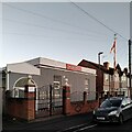
7
Evangelical Church building
Durbar Avenue Evangelical Church (affiliated to the Fellowship of Independent Evangelical Churches) is situated in the southern area of Holbrooks, Coventry.
Image: © Peter Mackenzie
Taken: 3 Jan 2017
0.18 miles
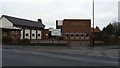
9
Foleshill Community Centre, Coventry
The community centre sits on the Foleshill Road and is well used by the local population.
Image: © Peter Mackenzie
Taken: 3 Jan 2017
0.19 miles
10
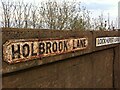
Signs on railway bridge where Holbrook Lane and Lockhurst Lane meet
Image: © A J Paxton
Taken: 11 Apr 2020
0.21 miles