IMAGES TAKEN NEAR TO
Awson Street, COVENTRY, CV6 5GG
Introduction
This page details the photographs taken nearby to Awson Street, CV6 5GG by members of the Geograph project.
The Geograph project started in 2005 with the aim of publishing, organising and preserving representative images for every square kilometre of Great Britain, Ireland and the Isle of Man.

There are currently over 7.5m images from over14,400 individuals and you can help contribute to the project by visiting https://www.geograph.org.uk
Image Map
Images are licensed for reuse under creativecommons.org/licenses/by-sa/2.0
Notes
- Clicking on the map will re-center to the selected point.
- The higher the marker number, the further away the image location is from the centre of the postcode.
Image Listing (44 Images Found)
Images are licensed for reuse under creativecommons.org/licenses/by-sa/2.0
Image
Details
Distance
2
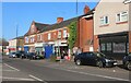
A S Purewall Wines, Stoney Stanton Road, Foleshill
This decrepit 19th century building stands at the junction of Stoney Stanton Road and Broad Street, Coventry. The decorative keystone lintels suggest that it might date from mid-century; the Freehold Land Society houses in similar style on Stoney Stanton Road date from the 1850s (see Fry, D & Smith A, The Coventry we have lost: Forgotten Foleshill, Simanda Press, 2018, pp91-92).
The ghostly remains of an advertisement painted on the stucco can still be made out: Bennett's Central Corn Stores, with Corn Merchant to the left and something very hard to make out to the right. David Ernest Bennett, corn dealer, is listed in Kelly's Directory between 1921 and 1940, according to the flickr user Hazel Nicholson, who posts a photo of this building here https://www.flickr.com/photos/10515323@N08/32895631286 . She identifies the building as 619 Stoney Stanton Road. The wine shop does not look as if it has done any business recently.
Image: © A J Paxton
Taken: 26 Aug 2021
0.05 miles
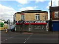
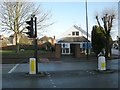
3
Junction of Broad Street & Stoney Stanton Road, Foleshill, Coventry
Broad Street, under its older name of Brick Kiln Lane, and Stoney Stanton Road were roads in the rural parish of Foleshill, which was settled by ribbon weavers and coal miners in the 18th and 19th centuries. The area was incorporated into Coventry in 1899, by which time it was rapidly being built up. (Fry, D & Smith, A, The Coventry we have lost: Forgotten Foleshill, Simanda Press, 2018, p23).
To the left in this picture, and with a small golden dome, can be seen the Ukrainian Catholic Church of St Wolodymyr, on the site of a Wesleyan chapel that was destroyed in the second world war Image On the far side of Stoney Stanton Road stands the building formerly occupied by Purewall Wines, which still carries the ghost of an advertisement for the corn merchant that occupied the premises in the earlier 20th century Image
The junction is overlooked by the 17-storey Falkener House block of flats, built by the city council and completed in 1968. Though not visible here, as it is behind the photographer, it can be seen in this geograph Image
Image: © A J Paxton
Taken: 26 Aug 2021
0.06 miles
4
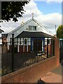
Ukrainian Catholic Church of St Wolodymyr the Great, Broad Street, Foleshill, Coventry
This church building opened in 1962 and stands on the site of a Wesleyan chapel that was built in 1839 and destroyed in the second world war. After 1945 the Methodists built on its site a wooden chapel which may form the basis of the current building; see the Victoria County History of Warwickshire Vol 8 pp382-396 https://www.british-history.ac.uk/vch/warks/vol8/pp382-396#h3-0017 .
Ukrainians settled in Coventry during and after the second world war, driven from their homeland by war and political persecution. Many were Catholics of the eastern or Byzantine rite, in communion with the Roman Catholic Church but worshipping according to a liturgy much closer to that of the Orthodox Church. Masses according to this rite were celebrated in Catholic parish churches in Coundon and later Foleshill until this church was built (ibid. pp368-371 https://www.british-history.ac.uk/vch/warks/vol8/pp368-371 )
St Wolodymyr is better known in the west by the Russian form of his name, Vladimir. He was a pagan ruler of Kyivan Rus', which encompassed peoples living in parts of what is now Ukraine, Belarus and Russia. His conversion to Christianity in the year 988 led to their becoming Christians. https://en.wikipedia.org/wiki/Vladimir_the_Great
Image: © A J Paxton
Taken: 26 Aug 2021
0.06 miles
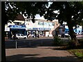
5
Coventry-Broad Street
The Church of Saint Vladimir The Great, which is Ukrainian Catholic Eastern Rite.
Image: © Ian Rob
Taken: 9 Jan 2008
0.07 miles
6
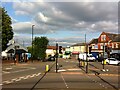
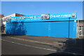
Discount Warehouse store, Stoney Stanton Road, Foleshill, Coventry
The Discount Warehouse and its neighbour, the Ali Baba Fish Bar & Kebab House, stand near the bend in Stoney Stanton Road (visible to the right) and are viewed from the forecourt of Falkener House, a housing tower block.
Image: © A J Paxton
Taken: 26 Aug 2021
0.07 miles
7
New Cheap Tyres on Stoney Stanton Road, Foleshill
Image: © David Howard
Taken: 21 May 2023
0.08 miles
8
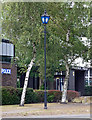
Police lamp, Stoney Stanton Road, Coventry
Quite a rare sight nowadays. It stands outside Foleshill Police Station.
Image: © Stephen Richards
Taken: 22 Aug 2011
0.09 miles
9
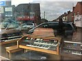
Greens Organs Ltd, Stoney Stanton Road, Foleshill
Abandoned electric organs and stools gather dust and fallen plaster in the showroom of Greens, which appears to have closed for good. Stoney Stanton Road and Crabmill Lane can be seen reflected in the shop window.
Image: © A J Paxton
Taken: 26 Aug 2021
0.10 miles
10
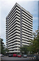
Falkener House, Stoney Stanton Road, Coventry
One of a number of similarly-styled tower blocks dotted about the northern fringes of Coventry, standing like sentries as if to provide early warning of incursions by Nuneaton or Hinckley. They are distinguished by projecting white concrete bands and closely resemble designs by City Architect, Arthur Ling. Built 1961.
Image: © Stephen Richards
Taken: 22 Aug 2011
0.10 miles