IMAGES TAKEN NEAR TO
Gressingham Grove, COVENTRY, CV6 5EN
Introduction
This page details the photographs taken nearby to Gressingham Grove, CV6 5EN by members of the Geograph project.
The Geograph project started in 2005 with the aim of publishing, organising and preserving representative images for every square kilometre of Great Britain, Ireland and the Isle of Man.

There are currently over 7.5m images from over14,400 individuals and you can help contribute to the project by visiting https://www.geograph.org.uk
Image Map (Loading...)


Getting Data...Please wait
Leaflet Map data © OpenStreetMap
Images are licensed for reuse under creativecommons.org/licenses/by-sa/2.0
Notes
- Clicking on the map will re-center to the selected point.
- The higher the marker number, the further away the image location is from the centre of the postcode.
Image Listing (51 Images Found)
Images are licensed for reuse under creativecommons.org/licenses/by-sa/2.0
Image
Details
Distance
2
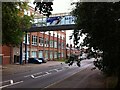
Former Courtaulds factory, Lockhurst Lane, Foleshill
The Lockhurst Lane 'bridge of sighs' connects two parts of Courtaulds textile works, which expanded along Lockhurst Lane in the years after 1918. The factory, which was known for making rayon and similar artificial fibres, closed in the 1990s and the surviving buildings have been put to a variety of commercial uses, with some converted to housing.
Image: © A J Paxton
Taken: 11 Sep 2021
0.04 miles
3
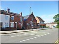
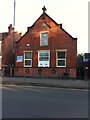
Foleshill Spiritualist Church
On Broad Street; the building is dated 1907.
Image: © Mike Faherty
Taken: 8 Jun 2014
0.06 miles
4
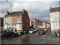
Coventry-Welford Place
Cul-de-sac off Lockhurst Lane.
Image: © Ian Rob
Taken: 29 Jun 2008
0.06 miles
5
Spiritualist Church, Broad Street, Foleshill, Coventry
The building is dated 1907 on the gable end.
Image: © A J Paxton
Taken: 16 Aug 2021
0.06 miles
6
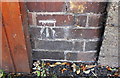
Benchmark on wall on west side of Lockhurst Lane
Ordnance Survey cut mark benchmark levelled at 95.921m above Newlyn Datum
Image: © Roger Templeman
Taken: 10 Jul 2018
0.07 miles
7
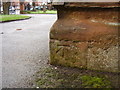
Benchmark on St Paul's Church
This bench mark was established in 1848 during the First primary levelling of England & Wales, and was levelled with a height of 328.4780 feet [100.1201 metres] above mean sea level (Liverpool datum). It was included on the Birmingham to London (Branch Levelling [from Coventry] to Foleshill and Sow Churches, &c.) levelling line. The surveyor's description was "No. 5. Foleshill Church. Bolt in North-west angle; 1.21 ft. above surface" (p.231). Much of the church was destroyed during World War II, but the present church incorporates the original 1841 tower.
Image: © Shantavira
Taken: 3 Apr 2015
0.07 miles
8
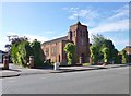
Foleshill, St. Paul's
Parish church on Foleshill Road: http://www.achurchnearyou.com/coventry-foleshill-st-paul-church/
Image: © Mike Faherty
Taken: 8 Jun 2014
0.08 miles
9
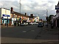
Foleshill Road looking south from Station Road junction towards St. Paul's Church
Image: © A J Paxton
Taken: 31 Jul 2021
0.08 miles
10
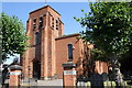
St Paul's Church, Foleshill Road
There is an OS benchmark Image at the base of a buttress on the near angle of the tower
Image: © Roger Templeman
Taken: 10 Jul 2018
0.08 miles