IMAGES TAKEN NEAR TO
Kingfield Road, COVENTRY, CV6 5AS
Introduction
This page details the photographs taken nearby to Kingfield Road, CV6 5AS by members of the Geograph project.
The Geograph project started in 2005 with the aim of publishing, organising and preserving representative images for every square kilometre of Great Britain, Ireland and the Isle of Man.

There are currently over 7.5m images from over14,400 individuals and you can help contribute to the project by visiting https://www.geograph.org.uk
Image Map
Images are licensed for reuse under creativecommons.org/licenses/by-sa/2.0
Notes
- Clicking on the map will re-center to the selected point.
- The higher the marker number, the further away the image location is from the centre of the postcode.
Image Listing (26 Images Found)
Images are licensed for reuse under creativecommons.org/licenses/by-sa/2.0
Image
Details
Distance
1
Ajit Darbar Sikh Temple, Lockhurst Lane, Foleshill
This gurdwara is dated 1962 on the front but the current building is clearly much more recent than that.
Image: © A J Paxton
Taken: 11 Sep 2021
0.08 miles
2
Vernacular houses, Lockhurst Lane
These two structures are the only obvious survivors of Lockhurst Lane buildings earlier than the late 19th century, and have been much extended with commercial frontages. Lockhurst Lane formed part of the parish of Foleshill and was a centre of the ribbon-weaving industry; one of the earliest co-operative societies was founded here in 1832. https://heartofengland.coop/society/roots/
Image: © A J Paxton
Taken: 21 May 2021
0.11 miles
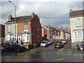
3
Tattoo parlour on Livingstone Road, Coventry
Image: © David Howard
Taken: 21 May 2023
0.12 miles
4
DSK electrical and lighting centre on Livingstone Road, Coventry
Image: © David Howard
Taken: 21 May 2023
0.12 miles
5
Buildings behind Park Street & Lockhurst Lane, Foleshill
This is an odd corner of Foleshill viewed through a fence from Livingstone Road. In the centre of the photo beyond the rather overgrown plot is what looks like a vernacular cottage with a crude modern extension and, behind it, some industrial buildings including a long factory building of brick.
Image: © A J Paxton
Taken: 11 Sep 2021
0.13 miles
6
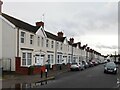
Former Coventry Corporation housing, Guild Road
These are some of the earliest council houses in Coventry, built by the city some time between 1907 and 1912. The very first row, on Pridmore Road, can be seen at the end of the street, on the right hand side of the photo, and also on this Geograph Image], which provides more information.
Image: © A J Paxton
Taken: 14 Jan 2023
0.13 miles
7
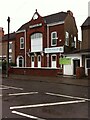
Mosque in premises of former Liberal Club
The Faizan-e-Islam mosque occupies the premises of the former Foleshill Liberal Club, which opened in 1891. https://forebears.io/england/warwickshire/foleshill#sid17390 At this time the Liberals were stronger than the Conservatives in Coventry, but they declined in the 1920s with the rise of the Labour Party. https://liberalhistory.org.uk/resources/coventry-history-centre/ The club closed in 2010. https://www.coventrytelegraph.net/news/coventry-news/foleshill-liberal-club-goes-liquidation-3056714
Image: © A J Paxton
Taken: 21 May 2021
0.13 miles
8
Coventry-Welford Place
Cul-de-sac off Lockhurst Lane.
Image: © Ian Rob
Taken: 29 Jun 2008
0.16 miles
9
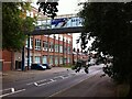
Former Courtaulds factory, Lockhurst Lane, Foleshill
The Lockhurst Lane 'bridge of sighs' connects two parts of Courtaulds textile works, which expanded along Lockhurst Lane in the years after 1918. The factory, which was known for making rayon and similar artificial fibres, closed in the 1990s and the surviving buildings have been put to a variety of commercial uses, with some converted to housing.
Image: © A J Paxton
Taken: 11 Sep 2021
0.18 miles
10
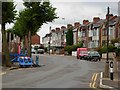
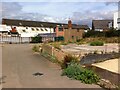
Kingfield Road, Coventry
Taken from the junction with Marion Road. The land on the left hand side is being redeveloped for housing and has been given the twee name 'Swallowcroft' by the builder.
Image: © Stephen McKay
Taken: 11 Aug 2006
0.18 miles