IMAGES TAKEN NEAR TO
St. Lukes Road, COVENTRY, CV6 4JH
Introduction
This page details the photographs taken nearby to St. Lukes Road, CV6 4JH by members of the Geograph project.
The Geograph project started in 2005 with the aim of publishing, organising and preserving representative images for every square kilometre of Great Britain, Ireland and the Isle of Man.

There are currently over 7.5m images from over14,400 individuals and you can help contribute to the project by visiting https://www.geograph.org.uk
Image Map (25 Images)


Getting Data...Please wait
Leaflet Map data © OpenStreetMap
Images are licensed for reuse under creativecommons.org/licenses/by-sa/2.0
Notes
- Clicking on the map will re-center to the selected point.
- The higher the marker number, the further away the image location is from the centre of the postcode.
Image Listing (25 Images Found)
Images are licensed for reuse under creativecommons.org/licenses/by-sa/2.0
Image
Details
Distance
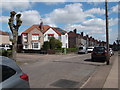
1
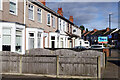
St Luke's Road, Holbrooks
The terraced houses on the left are caught by a burst of sunshine; one of them has recently been sold through Yopa. The 'no through road' sign is here because vehicular access to Hen Lane is blocked off.
Image: © Stephen McKay
Taken: 18 Nov 2022
0.06 miles
2
Foleshill Gas Tower as seen from Hen Lane
As seen on its final day before demolition.
Image: © Niki Walton
Taken: 21 Sep 2002
0.09 miles
3
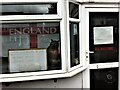
England - all welcome
You are welcome here - if you can get past the owl.
This was the former offices of City Gearboxes (Cov) Ltd on St Luke's Road in Holbrooks, Coventry.
Image: © A J Paxton
Taken: 26 Apr 2019
0.11 miles
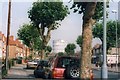
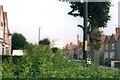
4
Briscoe Road, Holbrooks
Briscoe Road, with its mixture of semi-detached and terraced houses, bends away from Hen Lane in the Coventry suburbs.
Image: © Stephen McKay
Taken: 18 Nov 2022
0.12 miles
5
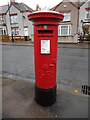
Postbox, Briscoe Road
Located at the point where Briscoe Road and Dymond Road meet.
Image: © Niki Walton
Taken: 14 Nov 2015
0.15 miles
6
Foleshill Gas Tower as seen from Dymond Road
The tower's final day of dominating the landscape before demolition early the next morning.
Image: © Niki Walton
Taken: 21 Sep 2002
0.16 miles
7
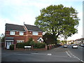
Houses, Alder Meadow Close
Part of a small estate of cul-de-sacs constructed in the late 1990s on the site formerly occupied by The Bantam public house on Hen Lane, Holbrooks, Coventry.
Image: © Niki Walton
Taken: 4 May 2017
0.17 miles
8
Junction of Dymond Road and Butlin Road
Part of a small estate of council housing built in 1936, the houses in the area are now a mix of owner-occupier, private rental, and housing association-owned homes.
Image: © Niki Walton
Taken: 22 Apr 2017
0.22 miles
9
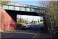
Hen Lane, Rowley's Green
The bridge here carries a freight only railway branch, originally built to serve Keresley Colliery but now running to Prologis Park. It is currently out of use.
Image: © Stephen McKay
Taken: 18 Nov 2022
0.22 miles
10
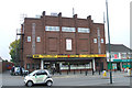
Lyric Building, Holbrook Lane
Now a Pound-Centre shop, this building was originally The Lyric Picture House and subsequently The Lyric Bingo Hall.
Image: © Niki Walton
Taken: 12 Oct 2007
0.23 miles