IMAGES TAKEN NEAR TO
Roland Mount, COVENTRY, CV6 4HP
Introduction
This page details the photographs taken nearby to Roland Mount, CV6 4HP by members of the Geograph project.
The Geograph project started in 2005 with the aim of publishing, organising and preserving representative images for every square kilometre of Great Britain, Ireland and the Isle of Man.

There are currently over 7.5m images from over14,400 individuals and you can help contribute to the project by visiting https://www.geograph.org.uk
Image Map
Images are licensed for reuse under creativecommons.org/licenses/by-sa/2.0
Notes
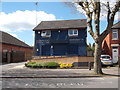
- Clicking on the map will re-center to the selected point.
- The higher the marker number, the further away the image location is from the centre of the postcode.
Image Listing (48 Images Found)
Images are licensed for reuse under creativecommons.org/licenses/by-sa/2.0
Image
Details
Distance
1
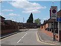
Forge Way
Forge Way, a cul-de-sac of Wheelwright Lane, constructed in the early 21st century.
Image: © Niki Walton
Taken: 22 Apr 2017
0.07 miles
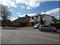
2
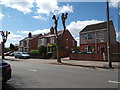
Houses, Wheelwright Lane
A variety of styles along this side of the road - detached and semi-detached here, in other places are short runs of terraced houses.
Image: © Niki Walton
Taken: 22 Apr 2017
0.09 miles
3
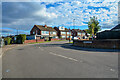
Coventry : Parkville Highway
Looking along a residential road off Nunts Lane.
Image: © Lewis Clarke
Taken: 25 Sep 2021
0.10 miles
4
Houses, Wheelwright Lane
A variety of styles along this side of the road - detached and semi-detached here, in other places are short runs of terraced houses.
Image: © Niki Walton
Taken: 22 Apr 2017
0.10 miles
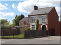
5
Houses, Wheelwright Lane
The detached white house was a newsagents shop for many years up to the late 1990s.
Image: © Niki Walton
Taken: 22 Apr 2017
0.10 miles
6
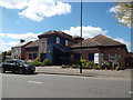
Holbrooks Primary Care Centre
On a site formerly occupied by derelict housing on Wheelwright Lane. An alleyway to Parkville Highway is just visible here to the right; out of shot on the other side of the alleyway entrance is Holbrooks Dental Centre.
Image: © Niki Walton
Taken: 22 Apr 2017
0.10 miles
7
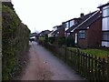
Footpath between Nunts Lane and Wheelwright Lane, Holbrooks
Seen at dusk, looking towards Wheelwright Lane. The building in the distance with hipped roofs is Holbrook Medical Centre. The white awning in front is part of a marquee in its car park erected for Covid-19 vaccination.
Image: © A J Paxton
Taken: 20 Apr 2021
0.10 miles
8
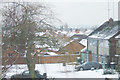
Snowy Rooftops, Holbrooks
Looking towards Wheelwright Lane and other Holbrooks residential streets beyond.
Image: © Niki Walton
Taken: 9 Feb 2007
0.11 miles
9
Holbrooks Dental Care
On Wheelwright Lane, on a site occupied by the St John's Ambulance Hall until around 1993.
Image: © Niki Walton
Taken: 22 Apr 2017
0.11 miles
10
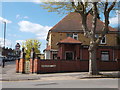
Doctor's surgery
A long-established GP surgery on the corner of Wheelwright Lane and Roland Avenue.
Image: © Niki Walton
Taken: 22 Apr 2017
0.12 miles