IMAGES TAKEN NEAR TO
Charlewood Road, COVENTRY, CV6 4EQ
Introduction
This page details the photographs taken nearby to Charlewood Road, CV6 4EQ by members of the Geograph project.
The Geograph project started in 2005 with the aim of publishing, organising and preserving representative images for every square kilometre of Great Britain, Ireland and the Isle of Man.

There are currently over 7.5m images from over14,400 individuals and you can help contribute to the project by visiting https://www.geograph.org.uk
Image Map
Images are licensed for reuse under creativecommons.org/licenses/by-sa/2.0
Notes
- Clicking on the map will re-center to the selected point.
- The higher the marker number, the further away the image location is from the centre of the postcode.
Image Listing (21 Images Found)
Images are licensed for reuse under creativecommons.org/licenses/by-sa/2.0
Image
Details
Distance
1
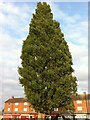
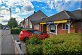
Lombardy Poplar, Everdon Road
A distinctive, lone, lombardy poplar growing on a green in front of a row of suburban shops on the oval-shaped Everdon Road, an estate of council housing in Coventry built in the late 1950s or early 1960s.
Image: © A J Paxton
Taken: 28 Aug 2018
0.10 miles
2
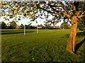
Football pitches, Holbrook Park
Holbrook Park faces onto Holbrook Lane to the east, while the football pitches at the west end are connected to Beake Avenue by a footpath. To the south are the Swallow Road industrial units, while to the north, visible in the distance, are the flats and houses of Everdon Road. Holbrook Park is a valuable green space for an otherwise densely built-up part of Coventry.
Image: © A J Paxton
Taken: 6 May 2018
0.11 miles
3
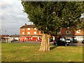
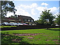
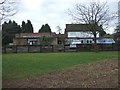
Row of shops facing onto a green on Everdon Road, Coventry
Everdon Road is a street of council housing built by Coventry City Council, probably in the late 1950s or early 1960s. It is oval in shape, with a short connecting road joining it to Holbrook Lane to the east, and has smaller closes branching off, forming a housing estate, for which this row of shops was intended as a shopping centre. It faces onto a green with a single lombardy poplar, at the western end of Everdon Road where it connects to Charlewood Road.
Image: © A J Paxton
Taken: 28 Aug 2018
0.12 miles
4
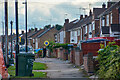
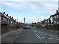
Coventry : Beake Avenue
Looking along the pavement.
Image: © Lewis Clarke
Taken: 25 Sep 2021
0.14 miles
5
The Craftsman
On the corner of Rotherham Road and Beake Avenue.
Image: © David Stowell
Taken: 27 Aug 2006
0.15 miles
6
Coventry : Harrington and Co
Estate agency on Headington Avenue.
Image: © Lewis Clarke
Taken: 25 Sep 2021
0.16 miles
7
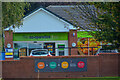
Coventry : Co-operative Food
Looking towards the shop on Rotherham Road.
Image: © Lewis Clarke
Taken: 25 Sep 2021
0.16 miles
9
The Craftsman public house, Coventry
On Beake Avenue.
Image: © JThomas
Taken: 4 Mar 2017
0.16 miles
10

Pillar Box at the junction of Beake Avenue and Rylston Avenue
Rylston Avenue was once on the boundary of the city. It now stands some distance inside. Beake Avenue is a well established, fairly typical Coventry residential road
Image: © Dave and Vicky
Taken: 24 Apr 2005
0.16 miles