IMAGES TAKEN NEAR TO
Foster Road, COVENTRY, CV6 3AS
Introduction
This page details the photographs taken nearby to Foster Road, CV6 3AS by members of the Geograph project.
The Geograph project started in 2005 with the aim of publishing, organising and preserving representative images for every square kilometre of Great Britain, Ireland and the Isle of Man.

There are currently over 7.5m images from over14,400 individuals and you can help contribute to the project by visiting https://www.geograph.org.uk
Image Map
Images are licensed for reuse under creativecommons.org/licenses/by-sa/2.0
Notes
- Clicking on the map will re-center to the selected point.
- The higher the marker number, the further away the image location is from the centre of the postcode.
Image Listing (11 Images Found)
Images are licensed for reuse under creativecommons.org/licenses/by-sa/2.0
Image
Details
Distance
1
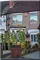
Coventry : Cheveral Avenue
Sunflowers at a house on Cheveral Avenue.
Image: © Lewis Clarke
Taken: 25 Sep 2021
0.09 miles
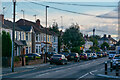
2
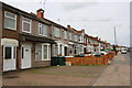
Odd numbered houses on Cheveral Avenue
Image: © Roger Templeman
Taken: 30 Apr 2018
0.09 miles
3
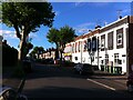
Coventry : Cheveral Avenue
At the road junction between Cheveral Avenue and Foster Road.
Image: © Lewis Clarke
Taken: 25 Sep 2021
0.10 miles
4

Cheveral Avenue
Cheveral Avenue is a long residential street of terraced houses running north from Middlemarch Rd to Jubilee Crescent.
Image: © Nigel Mykura
Taken: 13 Aug 2010
0.10 miles
5
Coventry : Cheveral Avenue
Shops on Cheveral Avenue.
Image: © Lewis Clarke
Taken: 25 Sep 2021
0.12 miles
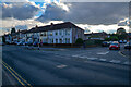
6
Heathcote Street, Radford, Coventry
Heathcote Street is a dead end street (though crossed by other roads), but will be familiar to anyone who has attended, or whose children have attended, one of the two primary schools near its far end, Hill Farm and St. Augustine's, a Catholic school. On the right hand side, and extending off the picture into Bulwer Road, are a group of houses whose brick facades have grand 'wild west' parapets concealing the conventional pitched roof behind. The corner house, with its array of wheelie bins, has been executed in blue engineering bricks.
Image: © A J Paxton
Taken: 9 Jun 2021
0.18 miles
7
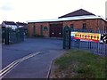
St. Augustine's Catholic church with church & school gates
St. Augustine's is a chapel of ease of Christ the King on Westhill Road in Coundon, and was constructed in 1979, apparently under the supervision of a member of the congregation, who was a structural engineer. It adjoins the primary school, part of which can be seen to the left of the church building. https://taking-stock.org.uk/building/radford-st-augustine/
Image: © A J Paxton
Taken: 9 Jun 2021
0.20 miles
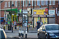
8
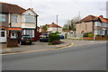
#135 Cheveral Avenue at Warden Road junction
Image: © Roger Templeman
Taken: 30 Apr 2018
0.21 miles
9
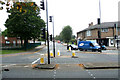
Looking down Beake Avenue from Radford Common
Image: © Niki Walton
Taken: 12 Oct 2007
0.21 miles
10
Coventry : Cheveral Avenue
Looking along Cheveral Avenue.
Image: © Lewis Clarke
Taken: 25 Sep 2021
0.21 miles