IMAGES TAKEN NEAR TO
Holloway Field, COVENTRY, CV6 2DB
Introduction
This page details the photographs taken nearby to Holloway Field, CV6 2DB by members of the Geograph project.
The Geograph project started in 2005 with the aim of publishing, organising and preserving representative images for every square kilometre of Great Britain, Ireland and the Isle of Man.

There are currently over 7.5m images from over14,400 individuals and you can help contribute to the project by visiting https://www.geograph.org.uk
Image Map (12 Images)


Getting Data...Please wait
Leaflet Map data © OpenStreetMap
Images are licensed for reuse under creativecommons.org/licenses/by-sa/2.0
Notes
- Clicking on the map will re-center to the selected point.
- The higher the marker number, the further away the image location is from the centre of the postcode.
Image Listing (12 Images Found)
Images are licensed for reuse under creativecommons.org/licenses/by-sa/2.0
Image
Details
Distance
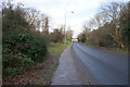
2
Benchmark on #263 Radford Road
Ordnance Survey cut mark benchmark levelled at 102.684m above Newlyn Datum
Image: © Roger Templeman
Taken: 30 Apr 2018
0.13 miles
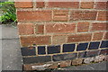
3
#263 Radford Road
There is an OS benchmark Image on the near corner, right hand face, of the house
Image: © Roger Templeman
Taken: 30 Apr 2018
0.13 miles
4
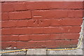
Benchmark on #134 Three Spires Avenue
Ordnance Survey cut mark benchmark levelled at 105.641m above Newlyn Datum
Image: © Roger Templeman
Taken: 30 Apr 2018
0.18 miles
5
#134 Three Spires Avenue
There is an OS benchmark Image on the side of the house near its front corner
Image: © Roger Templeman
Taken: 30 Apr 2018
0.18 miles
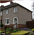
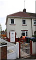
6

Radford House on Brownshill Green Road, Coundon
Image: © David Howard
Taken: 21 May 2023
0.19 miles
7
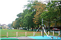
Radford Common, Radford Road
Looking across the new play area on Radford Common to Radford Road (B4098).
Image: © Niki Walton
Taken: 12 Oct 2007
0.21 miles
8
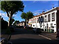
Heathcote Street, Radford, Coventry
Heathcote Street is a dead end street (though crossed by other roads), but will be familiar to anyone who has attended, or whose children have attended, one of the two primary schools near its far end, Hill Farm and St. Augustine's, a Catholic school. On the right hand side, and extending off the picture into Bulwer Road, are a group of houses whose brick facades have grand 'wild west' parapets concealing the conventional pitched roof behind. The corner house, with its array of wheelie bins, has been executed in blue engineering bricks.
Image: © A J Paxton
Taken: 9 Jun 2021
0.21 miles
9

Junction of Radford Road and Brownshill Green Road
Seen from Greyfriars Court. Brownshill Green Road can be seen in the centre of the photo, bending sharply to the right a short distance away from the roundabout. To the left, by the garages and the block of flats, can be seen the junction with Holloway Field and, behind it, the junction with Scots Lane. At the bottom left of the photo can be seen the start of the dual carriageway section of Radford Road that descends the slope towards Radford Common and the city centre.
Image: © A J Paxton
Taken: 1 Jul 2012
0.22 miles
10

Greyfriars Court from Brownshill Green Road
The two three-storey blocks of flats jointly called Greyfriars Court stand at right angles to each other. One faces onto Brownshill Green Road at its junction with Radford Road, and its front elevation can be seen in the centre of this photo. The other fronts onto Sadler Road at its junction with Radford Road, and its side elevation and a little of its rear can be seen to the right of the other block, with two-storey terraced houses beyond it on Sadler Road.
Image: © A J Paxton
Taken: 1 Jul 2012
0.23 miles